 Trace Elements in West Virginia Coals
Trace Elements in West Virginia Coals
Trace Elements in West Virginia Coals Arsenic (As)
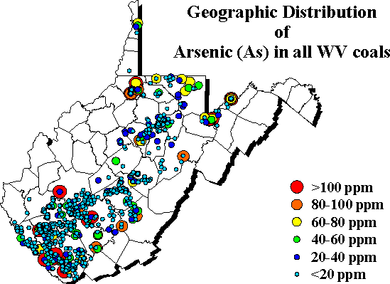 The
geographic distribution of whole coal arsenic abundance shows high arsenic
in Conemaugh coals of Tucker, Mineral and Grant counties (see
cautionary notes page) and "possible" high arsenic regions in western
McDowell and southwestern Wyoming counties where lower Kanawha coals are
mined, and in Greenbrier and Lewis counties. Coals over most of the
state were <10 ppm whole coal arsenic.
The
geographic distribution of whole coal arsenic abundance shows high arsenic
in Conemaugh coals of Tucker, Mineral and Grant counties (see
cautionary notes page) and "possible" high arsenic regions in western
McDowell and southwestern Wyoming counties where lower Kanawha coals are
mined, and in Greenbrier and Lewis counties. Coals over most of the
state were <10 ppm whole coal arsenic.
![]()
![]()
![]()
![]()
| To request specific information from a Survey geologist click here. |

Page last revised: March 1, 2002
Please send questions, comments, and/or suggestions to webmaster.
Page created and maintained by:
            West Virginia Geological & Economic Survey
  Address:  Mont Chateau Research Center
            Cheat Lake exit off I-68
            P.O. Box 879
            Morgantown, WV  26507-0879
Telephone:  1-800-WV-GEOLOgy (1-800-984-3656) or 304-594-2331
      FAX:  304-594-2575
    Hours:  8:00 a.m. - 5:00 p.m. EST, Monday - Friday
Permission to reproduce this material is granted if acknowledgment is given to the West Virginia Geological and Economic Survey.