 Trace Elements in West Virginia Coals
Trace Elements in West Virginia Coals
Trace Elements in West Virginia Coals Antimony (Sb)
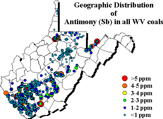 The
geographic distribution of whole coal antimony abundance shows low values
(<2 ppm) over most of West Virginia. A "possible" region of higher
(2-3 ppm) antimony occurs along the southeastern edge of the southern coalfield
from Randolph to Raleigh counties, coinciding with areas where the Pocahontas
No. 6, Fire Creek and Beckley coals were mined (note the antimony
The
geographic distribution of whole coal antimony abundance shows low values
(<2 ppm) over most of West Virginia. A "possible" region of higher
(2-3 ppm) antimony occurs along the southeastern edge of the southern coalfield
from Randolph to Raleigh counties, coinciding with areas where the Pocahontas
No. 6, Fire Creek and Beckley coals were mined (note the antimony
| To request specific information from a Survey geologist click here. |

Page last revised: March 1, 2002
Please send questions, comments, and/or suggestions to webmaster.
Page created and maintained by:
            West Virginia Geological & Economic Survey
  Address:  Mont Chateau Research Center
            Cheat Lake exit off I-68
            P.O. Box 879
            Morgantown, WV  26507-0879
Telephone:  1-800-WV-GEOLOgy (1-800-984-3656) or 304-594-2331
      FAX:  304-594-2575
    Hours:  8:00 a.m. - 5:00 p.m. EST, Monday - Friday
Permission to reproduce this material is granted if acknowledgment is given to the West Virginia Geological and Economic Survey.