
The Well Header Data Search application allows the user to query oil & gas header records in our system through the given fields on the form. Once the user enters their selection criteria and hits the search button, the matching header records are then returned. When performing a query on multiple fields, it is treated with an "and" operator in the search. This means that criteria entered in all fields must be met. The default value for each search field is set to null which will return all records. However, you must enter/select at least one condition for the application to run, but not any one field condition is required. The form is made up of 4 types of searches: numeric searches (Num), character searches (Char), pull-downs and checkboxes. Below are the fields of the oil & gas header data search form with type of searches and requirements to perform searches on each field.
| Field | Type of search | Requirement |
|---|---|---|
| API # | Num | 10 Digit Num between 4700100001 and 4710999999, looks for an exact match |
| County | Pull Down | Pull Down - select one if desired |
| 7.5 Minute Quad | Pull Down | Pull Down - select one if desired |
| Type of Scanned Log | Pull Down | Pull Down - select one if desired |
| Scanned Log Bottom (ft) >= | Num | 4 or 5 digit Num between 1000 and 15000 |
| has Scanned Log(s) | Checkbox | Checkbox - checked (Yes), unchecked (No/Null) |
| has Digitized Log(s) | Checkbox | Checkbox - checked (Yes), unchecked (No/Null) |
| has Slabbed Core Photo(s) | Checkbox | Checkbox - checked (Yes), unchecked (No/Null) |
| Horizontal/Deviated Well | Checkbox | Checkbox - checked (Yes), unchecked (No/Null) |
| Well Type | Pull Down | Pull Down - select one if desired |
| Total Vertical Depth TVD (ft) >= | Num | 4 or 5 digit Num between 1000 and 15000 |
| Completion Year = | Num | 4 digit Num between 1850 and 2027, looks for an exact match |
| Operator at Completion (contains) | Char | contains character search, minimum 3 characters if searching |
| Last Producing Operator (contains) | Char | contains character search, minimum 3 characters if searching |
| Surface Owner (contains) | Char | contains character search, minimum 3 characters if searching |
| Field Name | Pull Down | Pull Down - select one if desired |
| Company Number (contains) | Char | contains character search, minimum 3 characters if searching |
| Mineral Owner (contains) | Char | contains character search, minimum 3 characters if searching |
| Unit/Lease Name (contains) | Char | contains character search, minimum 3 characters if searching |
An example of a search would be if you wanted to see all wells in Barbour county, with a total depth greater than or equal to 5000 feet and with a surface owner name of Smith. You would enter the search criteria and the form should look similar to the following display. Please note you have the option to change the number of records returned per page within the form by changing the selection in the "Results/Page" pull-down. You also have several sorting options available in the "Order By" pull-down.
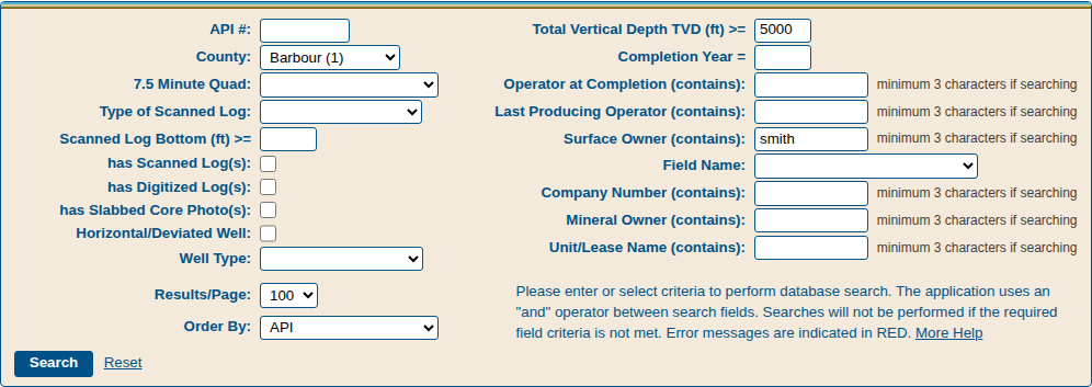
You would then hit the search button and the application would return the resulting records similar to below.

The resulting data is our header records for each well that met your search criteria. Latitude and longitude coordinates for wells are provided in NAD83 datum. The system will also provide a link to "pipeline" and other system applications to provide more complete well info if the data are available. To use the link to "pipeline" just hit the "All Data" link for that record. Sometimes you may see more than one record for one particular well. This is due to multiple episodes of the well, for instance if the well is worked over or deepened.
The results table
Each row of the results is one header record, that is, one episode of a well. The first columns after the API # are links, which open in a second browser tab:
- Pipeline: "All Data" opens all of the well’s data in "pipeline".
- Map: "View" shows the well on the WVGES interactive map.
- ELog: "Elog" opens the Digital Records Search with the well’s scanned logs.
- DLog: "Dlog" opens the Digital Records Search with the well’s digitized logs.
- Scans: "Scans" opens the Digital Records Search with all of the well’s digital records.
A link is shown only when the well has that kind of data. The remaining columns are described in the table below.
Download to Excel: when a search finds 1,000 wells or fewer, "Download all wells (Excel)" above the results saves every matching well as an Excel workbook with four sheets: Read Me (the date and your search criteria), Disclaimer, Well Header Data (one row for each record, with a link to the well in "pipeline") and Field Descriptions. For a larger search, add search criteria to narrow it.
Field descriptions
Below are the field descriptions for the results (the Oil & Gas Header record table) and the Excel download. A few columns have slightly different names in the results table: API # (API), Scanned Logs (LOGS), Comp # (COMPANY #) and Elevation (ELEV).
| Column | Full name | Description |
|---|---|---|
| API | American Petroleum Institute Well Number | well number assigned by the state regulatory authority, conforming to a national format: 2-digit state code, 3-digit county code padded with leading zeroes, and 5-digit permit number padded with leading zeroes |
| COUNTY | County Name | name of the county in which the surface of the well exists |
| DD LONG | Surface Location Longitude in Decimal Degrees | location of the surface of the well - west longitude, in decimal degrees west of the Prime Meridian; depicted as a negative value |
| DD LAT | Surface Location Latitude in Decimal Degrees | location of the surface of the well - north latitude, in decimal degrees north of the equator |
| UTME | Surface Location UTM-Easting | location of the surface of the well - UTM easting coordinate measured in meters east of the principal meridian in UTM Zone 17; NAD83 |
| UTMN | Surface Location UTM-Northing | location of the surface of the well - UTM northing coordinate measured in meters north of the baseline in UTM Zone 17; NAD83 |
| 7.5 QUAD | 7.5' Quadrangle Name | 7.5' quadrangle name for the surface location of the well |
| TAX DISTRICT | Tax District | tax district name in the county |
| LOGS | Electric Logs Available at WVGES | indicates the availability of specific e-logs in the WVGES log repository; available for free download from the WVGES website |
| LOG BTM | Log Bottom (ft) | bottom of the total logged interval, in feet below surface datum |
| SUFFIX | Suffix | designation for the episode of drilling for the well |
| STATUS | Status | designation of the status of this episode of drilling as permitted, completed, or cancelled |
| COMP YEAR | Completion Year | year of completion (yyyy) |
| WELL TYPE | Well Type | type of well, summarized in this episode of drilling |
| OPERATOR AT COMPLETION | "Operator at Completion" or "Operator when Permitted" | name of the operator/company which owned the well (or the party responsible for the well) at the time the well was drilled or when the well was permitted |
| LAST PRODUCING OPERATOR | Last Producing Operator | name of the last operator/company reporting production for the given well |
| SURFACE OWNER | Surface Owner Name (Farm Name) | name of the surface owner of the well |
| WELL # | Well Number | well number on the farm as assigned by the operator to identify the well |
| COMPANY # | Company Number | operator's number for the well |
| MINERAL OWNER | Mineral Owner | name of the reported owner of the oil and gas rights on the property where the well is located |
| UNIT/LEASE NAME | Unit/Lease Name | the entity which is reported as owning the oil and gas rights on the property where the well is located |
| LEASE # | Lease Number | lease number |
| TVD | Total Vertical Depth (TVD) on the Completion Report (ft) | total vertical depth of the well, measured in feet from the surface datum to the bottom of a vertical well |
| MD | Total Measured Depth (TMD) on the Completion Report (ft) | total footage drilled in a horizontal well, measured in feet from the surface datum to the end of the well bore |
| DEEPEST FM | Deepest Formation Penetrated | deepest formation penetrated; formation at the bottom of a well |
| FIELD | Field Name | name of the oil and gas field, assigned by a WVGES geologist |
| ELEV | Elevation (ft) | elevation of the surface of the well, in feet above mean sea level |