additional links

Sponsors


Field Trips
Download a PDF of information from this page here 
Click on a title below to expand/condense information.
+
Rifts, Diabase, and the Topographic "Fishhook": Terrain and Military
Geology of the Battle of Gettysburg -- July 1 - 3, 1863
Saturday, June 28, 2008, 8:30 AM to 5 PM
Field Trip Leaders: Roger J. Cuffey, Jon D. Inners, Robert C. Smith II, Gary M. Fleeger and Richard C. Keen
 Travel to Gettysburg, PA via bus for a day-long trip featuring geology and its influence on history. The battle of Gettysburg was the greatest military engagement ever fought on the North American continent. This is "historical fact"-born out not only by the numbers but also by the military, political, and economic ramifications of its outcome. 155,000 men fought here on those three July days of 1863 (85,000 on the Union side, 70,000 on the Confederate); 7,000 of them died (3,100 Union, 3,900 Confederate); and another 44,000 were casualties of one sort or another (19,900 Union, 24,100 Confederate). These are catastrophic numbers for any 19th-century battle-and certainly the highest for any fought in the American Civil War. Militarily, if the North had not won decisively at Gettysburg (even considering Grant's victory at Vicksburg), a disgusted Army, if not an aroused citizenry, may have forced the Federal government to sue for peace. Politically, even a compromise that did not split one nation into two would have destroyed American constitutional federalism and greatly weakened our role on the world stage. Economically-compromise or split-two unchecked oligarchies, an industrial one in the North and an agricultural one in the South, would have been greatly strengthened-and the "common man" in both relegated to impotence. But the North did win-and four and a half months later, Abraham Lincoln enshrined Gettysburg into the American canon with a speech that is, in its entirety, the most memorable of all time.
Our interest on this field trip is in the military aspects of the battle of Gettysburg-and particularly on the "historical fact" of the geography and geology of the region and locale over which the campaign and battle developed. A major reason for Gettysburg being "the most studied military action in the world" (Kross, 2000) is the importance of terrain considerations in the strategies and tactics adopted by the two opposing armies, the North's Army of the Potomac and the South's Army of Northern Virginia. Just as the name "Gettysburg" resonates down through American history (McPherson, 2003), so do "Little Round Top," "Devil's Den," "Cemetery Ridge," "Seminary Ridge," and the "Wheatfield." One of the reasons that both German and Japanese military experts visited the new "Electric Map" at Gettysburg in the late 1930's was to study in depth a battle and campaign that showed so clearly how West Pointers interpreted landscape in the past-certainly, in Huttonian terms, a key to how they might interpret it in the present.
Lunch: There will be a box lunch from the National Training Center for those covered by the Meal Plan. Anyone not covered by the Meal Plan needs to make arrangements to purchase a lunch from the Center or bring a lunch. Please indicate your preference for sandwich type (turkey, roast beef, vegetarian or ham) on the registration form.
Cost: $40 includes transportation and guidebook. Spouses and guests are welcome to attend.
+
The History and Geology of the Harpers Ferry Region, West Virginia, Maryland, and Virginia
Monday, June 30, 2008 8:30 AM to 11:30 AM
Field Trip Leaders: Scott Southworth and David Brezinski
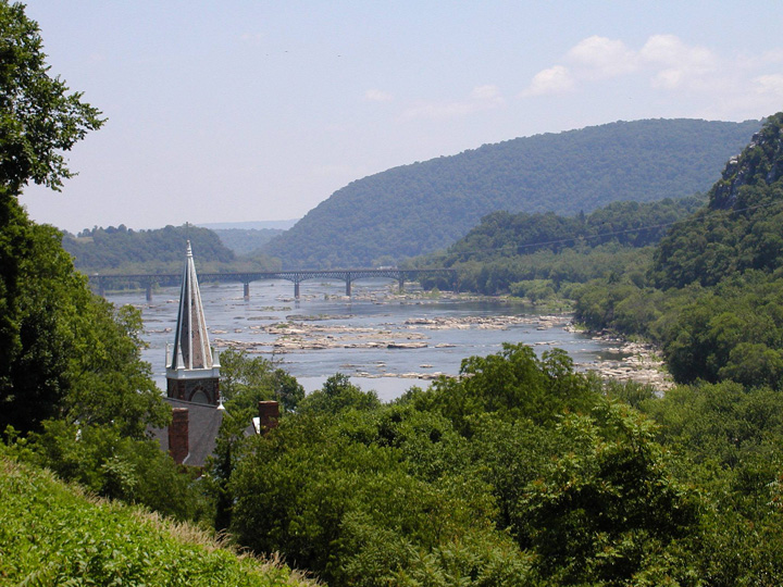 Visit historic Harpers Ferry, WV, at the confluence of the Potomac and Shenandoah rivers, where geology influenced some of the historic
events that have occurred here.
http://www.nps.gov/hafe/
Visit historic Harpers Ferry, WV, at the confluence of the Potomac and Shenandoah rivers, where geology influenced some of the historic
events that have occurred here.
http://www.nps.gov/hafe/
Travel to nearby Harpers Ferry via bus. The Harpers Ferry, West Virginia, region, has been a cradle for eastern North American geology for more than 120 years. It has served as a laboratory for field investigations and cooperative research by Federal, State, and University scientists. This water gap through the Blue Ridge at the confluence of the Potomac and Shenandoah Rivers has played a prominent role in the early history of our nation. The boundary between the Great Valley section of the Valley and Ridge province and the Blue Ridge province is to the immediate west. The boundaries between West Virginia, Maryland, and Virginia are shared along the south bank of the Potomac River just east of Harpers Ferry. The geologic insight gained here has been applied from Pennsylvania to Georgia.
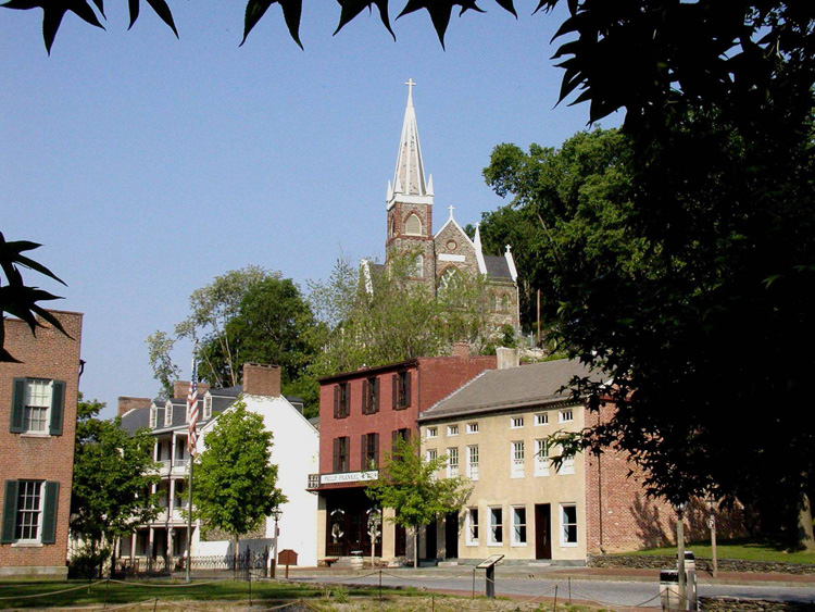 After an introduction to the history and geology of the Harpers Ferry National Historic Park, participants will have time to explore the park on their own. The "Lower Town" is flat and easy to walk in. Visiting the "Upper Town" and places such as Jefferson Rock involves walking up some steep hills.
Cost: $20 includes transportation and guidebook.
+ Appalachian Geology Transect From the Piedmont Province West to the Valley and Ridge Province
Wednesday, July 2, 2008 8:30 AM to 5 PM
Field Trip Leaders: Scott Southworth, Randy Orndorff, David Brezinski, and David Weary
 Travel via bus. This trip is an east to west transect across the Central Appalachians of the Mid-Atlantic region from the Piedmont
province, westward across the Blue Ridge province, and the Great Valley section, into the central Valley and Ridge province. From the National
Conservation Training Center in the Shenandoah Valley, the trip crosses the Blue Ridge-South Mountain anticlinorium, the Mesozoic
Culpeper/Gettysburg basin, Frederick Valley, and Westminster terrane of the western Piedmont en route to Great Falls Park, Virginia, for Stop 1.
Here we will examine the complex metasedimentary rocks of the Potomac terrane associated with the Ordovician Taconian orogeny, as well as late
Pleistocene fluvial landforms carved by the Potomac River. The excursion travels west across the Piedmont and Culpeper basin to Shenandoah
National Park, Virginia, where stop 2 is on the west limb of the Blue Ridge-South Mountain anticlinorium. Here the oldest (1.1 Ga) rocks of the
region are exposed in a late Paleozoic fold that is related to the Alleghanian orogeny. A short drive west to Tumbling Run in the Great Valley,
at stop 3 we will examine Middle Ordovician strata that record the end of carbonate platform deposition and evidence of the Taconian orogeny
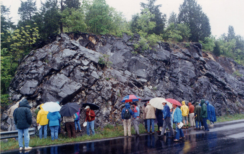
discussed at stop 1. The excursion then travels northwest to the Sideling Hill syncline in the Valley and Ridge province, Maryland, where
stop 4 is a spectacular roadcut through a late Pennsylvanian syncline exposing late Devonian glacial diamictite, unconformably overlain by early Mississippian
clastic rocks and coal beds. These rocks were being deposited on a broad coastal plain while the rocks of the Blue Ridge and Piedmont were
undergoing metamorphism, deformation, and transport to the west.
Travel via bus. This trip is an east to west transect across the Central Appalachians of the Mid-Atlantic region from the Piedmont
province, westward across the Blue Ridge province, and the Great Valley section, into the central Valley and Ridge province. From the National
Conservation Training Center in the Shenandoah Valley, the trip crosses the Blue Ridge-South Mountain anticlinorium, the Mesozoic
Culpeper/Gettysburg basin, Frederick Valley, and Westminster terrane of the western Piedmont en route to Great Falls Park, Virginia, for Stop 1.
Here we will examine the complex metasedimentary rocks of the Potomac terrane associated with the Ordovician Taconian orogeny, as well as late
Pleistocene fluvial landforms carved by the Potomac River. The excursion travels west across the Piedmont and Culpeper basin to Shenandoah
National Park, Virginia, where stop 2 is on the west limb of the Blue Ridge-South Mountain anticlinorium. Here the oldest (1.1 Ga) rocks of the
region are exposed in a late Paleozoic fold that is related to the Alleghanian orogeny. A short drive west to Tumbling Run in the Great Valley,
at stop 3 we will examine Middle Ordovician strata that record the end of carbonate platform deposition and evidence of the Taconian orogeny
discussed at stop 1. The excursion then travels northwest to the Sideling Hill syncline in the Valley and Ridge province, Maryland, where
stop 4 is a spectacular roadcut through a late Pennsylvanian syncline exposing late Devonian glacial diamictite, unconformably overlain by early Mississippian
clastic rocks and coal beds. These rocks were being deposited on a broad coastal plain while the rocks of the Blue Ridge and Piedmont were
undergoing metamorphism, deformation, and transport to the west.
Lunch: There will be a box lunch from the National Training Center for those covered by the Meal Plan. Anyone not covered by the Meal Plan needs to make arrangements to purchase a lunch from the Center or bring a lunch. Please indicate your preference for sandwich type (turkey, roast beef, vegetarian or ham) on the registration form.
Cost: $40 includes transportation and guidebook.