 Geoscience Education in the Mountain State:
CATS Geology Telecourse, Spring 1999,
Article--Volcanic Ash in West Virginia
Geoscience Education in the Mountain State:
Volcanic Ash in West Virginia
Alan F. Keiser
Bascombe M. Blake, Jr.
William C. Grady
Ash from an ancient volcano is quite helpful to modern coal geologists.
On May 18, 1980, a violent volcanic explosion occurred when Mount St. Helens erupted in the state of Washington. The enormous force of the explosion leveled entire forests for many square miles around the mountain, created large mudflows that blocked roads and streams, and sent huge quantities of volcanic ash into the atmosphere. When the ash fell back to Earth, it formed a layer from about one foot thick near Mount St. Helens to less than an inch thick hundreds of miles east (downwind) of the mountain. At least 60 people and countless animals and plants died, primarily from the suffocating ashfall. Surface and air transportation was severely hindered as the ash clogged automobile air filters and jet turbines.
About 300 to 310 million years ago, during the Middle Pennsylvanian epoch when vast peat swamps were forming in southern West Virginia, a similar but much larger volcanic explosion occurred along what is now the east coast of the United States. The prehistoric eruption generated huge quantities of volcanic ash which fell on southern West Virginia and several bordering states (Figure 1). As the ash fell, the environment must have been smelly, gritty, and thoroughly unpleasant for any primitive land creatures such as the amphibians living at that time. (For an idea of what the State's environment was like during the Pennsylvanian, see the articles "300 Million Year Old Footprints Found in Tucker County" in the 1982 issue of Mountain State Geology, and "Fossil Footprints Unearthed in Eastern Panhandle" in the 1988 issue.)
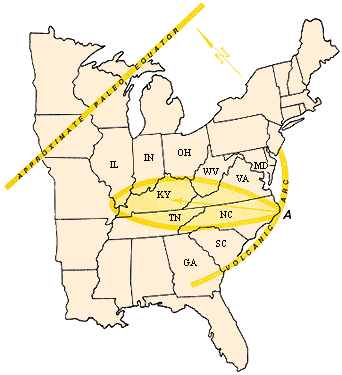 Figure 1. Probable source area ("A" on the volcanic arc) and ashfall distribution (oval) of the Hernshaw flint clay, 310 million
years ago (mid-Pennsylvanian age). Location of the Earth's paleoequator at that time is approximate. Arrow indicates probable
Trade Wind direction during the winter.(Adapted from Chesnut, 1983. See Reference.) (Illustration by Paul Liston)
Figure 1. Probable source area ("A" on the volcanic arc) and ashfall distribution (oval) of the Hernshaw flint clay, 310 million
years ago (mid-Pennsylvanian age). Location of the Earth's paleoequator at that time is approximate. Arrow indicates probable
Trade Wind direction during the winter.(Adapted from Chesnut, 1983. See Reference.) (Illustration by Paul Liston)
Distribution of the Ash
Volcanic ash is not really ash, but pulverized rock ejected from a volcano. Most of this pulverized rock was volcanic glass which fell over various land and water surfaces. Not all of the ash was preserved as an intact layer. Some of it was eroded, and some was mixed with sediments such as sand, silt, and clay; in either case the ash became unrecognizable in the rock record.
However, certain environments were fairly quiet and stable at the time of the eruption and ashfall. These were the widespread peat swamps that covered parts of southern West Virginia which were ideal for preserving the accumulated ash layer. The peat later became a coal seam which geologists in West Virginia call the Hernshaw coal bed (Fire Clay bed in eastern Kentucky).
The Hernshaw Flint Clay
Volcanic glass is formed when a certain type of molten rock is cooled very rapidly. Rapid cooling prevents the formation of a crystalline structure, resulting in a chemically unstable (non-crystalline) structure. Old window panes demonstrate the unstable nature of glass by "flowing," which distorts the view and makes everything appear wavy. This distortion is the first, short-term indication of the unstable nature of glass.
The chemically unstable volcanic glass in the ashfall was rapidly altered to the clay mineral kaolinite in the acid waters of the peat swamp. The kaolinite crystals that formed were very fine-grained, resulting in the formation of a flint clay or tonstein (clay stone). In outcrop, the Hernshaw flint clay is fairly hard, resistant to weathering, has a conchoidal fracture (smooth, curved surfaces), and is flinty in appearance (thus the name flint clay). The flint clay varies in thickness from zero to six inches in West Virginia, but generally is two to three inches thick. The original ash layer was much thicker, but was compressed and altered over time to form a thinner flint clay. The flint clay's color is usually light- to dark-brownish gray; in places it is almost black.
The Hernshaw flint clay is found within the minable Hernshaw coal or the black carbonaceous shale below the main Hernshaw coal. Flint clay occurrences vary geographically. It has been traced from northeastern Tennessee through eastern Kentucky, southern West Virginia, and along the northwest edge of western Virginia.
Source Area of the Volcano
The location of the volcanic source for the Hernshaw flint clay is interesting and certainly somewhat speculative. D.R. Chestnut (see reference) cites the source area as being along what is now the coast of North Carolina (Figure 1). The likely source area has long been eroded and buried beneath younger sediments of the coastal plain. Some 310 million years ago, a volcanic arc was formed at a subduction zone (an area of the Earth's crust which descends and is pushed beneath another area of the Earth's crust) along what is now the east coast of the United States (see the article "Mountains" in the 1988 issue of Mountain State Geology). West Virginia was located slightly south of the equator at that time and was rotated approximately 45 degrees clockwise compared to its present position. (This is known from fossil evidence, paleomagnetic data, and from the theory of continental drift.) The prevailing Trade Winds along the equator which dispersed the Hernshaw volcanic ash blew toward the northwest during the winter (Chestnut, 1983).
What evidence is there to indicate a volcanic origin for the Hernshaw flint clay? The flint clay is found over a large geographic area, is fairly uniform in thickness, and lacks sedimentary or nonvolcanic minerals other than kaolinite (generally an alteration mineral). This suggests deposition by non-water-borne transportation processes. Generally, the upper and lower contacts of the Hernshaw flint clay are sharp, thus representing a very rapid depositional event. If the flint clay had been deposited by water over a long period of time, the contacts with overlying and underlying rock units (beds) would most likely be gradational.
The scanning electron microscope (SEM) located at the analytical laboratory of the West Virginia Geological and Economic Survey has been a valuable tool in interpreting the composition and origin of the flint clay. The SEM not only allows us to see the minute crystals which make up the flint clay, but also to identify these minerals by their chemical composition.
Quartz is an important mineral in the flint clay as well as sedimentary rocks such as sandstone. Zircon, often used as a gemstone, is another mineral typical of the flint clay.
How is the Hernshaw flint clay useful? Most sedimentary rocks were deposited over extended periods of time and over small geographic areas, making their regional relationships difficult to interpret. But the Hernshaw flint clay was deposited in a very short period of time and over a very wide area, thus making it an excellent time-rock marker unit for correlating coal seams and associated strata.
The Hernshaw flint clay, as a correlation tool, has been of great help in understanding coal seam correlations of the stratigraphically complex Kanawha Formation in southern West Virginia. In certain areas, the Hernshaw coal seam has been incorrectly identified as the Chilton or Cedar Grove coal seam in the past. Coal geologists and mining engineers recognize the importance of correct coal seam correlations when they evaluate coal reserves for a given area.
The different positions of the flint clay parting in the Hernshaw coal seam indicate that the Hernshaw peat swamp was in different stages of development over a large area when the volcanic ash fell. It is very possible that other volcanic eruptions occurred during Pennsylvanian time and perhaps volcanic flint clays in other coal seams were preserved. Using the above techniques to identify them as volcanic, these additional flint clays could be used as an additional tool to correlate other coal seams in southern West Virginia.
Chestnut, D.R., 1983, Source of the volcanic ash deposit (flint clay) in the Fire Clay coal of the Appalachian Basin: Compte Rendu, vol. A, 10th International Congress of Carboniferous Stratigraphy and Geology, Madrid, p. 145-154.
Volcanic Origin of the Flint Clay Parting in the Hazard No. 4 (Fire Clay) Coal Bed of the Breathitt Formation in Eastern Kentucky: B.F. Bohor and D.M. Triplehorn, in Coal and Coalbearing Rocks of Eastern Kentucky, 1981, Kentucky Geological Survey, GSA Coal Division fieldtrip guidebook, p. 49-54. Presents definitive mineralogical data from the flint clay parting of the Fire Clay (Hernshaw) coal bed to indicate a volcanic origin. Written for geologists.
Tonsteins in the Coalfields of Western Europe and North America: K. Burger and H.H. Damberger, in Compte Rendu, vol. 4, 1979, Ninth International Congress on Carboniferous Stratigraphy and Geology, Champaign-Urbana, p. 433-448. Discusses the terminology, importance and usefulness of tonsteins (flint clays) and depicts their regional and stratigraphic distributions in the coalfields of western Europe and North America. Written for geologists.
Pyroclastic Rocks: R.V. Fisher and H.U. Schminke, 1984, Springer-Verlag, New York, 472 p. Detailed summary of pyroclastic rocks, their physical aspects, and stratigraphic relationships. Written for geologists.
300 Million Year Old Footprints Found in Tucker County: T.R. Jake and B.M. Blake, in 1982 Mountain State Geology magazine, p. 23-25. Article on the 1982 discovery of well-preserved, fossilized amphibian footprints near Thomas, WV. Explains how the fossils formed and were preserved. Publication MSG-82.
Fossil Footprints Unearthed in Eastern Panhandle: S.W. McClelland, in 1988 Mountain State Geology magazine, p. 14-17. Article on the 1986 discovery of fossilized amphibian trackways in Mineral County, WV.
Mountains: J.F. Schwietering, in 1988 Mountain State Geology magazine, p. 29-39. Concise overview of types of mountains and the Earth processes that form them. Publication MSG-88.
WVGES Education Specialist, Tom Repine (repine@wvgs.wvnet.edu)
Page last revised: July 1999
Please send questions, comments, and/or suggestions to webmaster@wvgs.wvnet.edu
Page created and maintained by:
            West Virginia Geological & Economic Survey
  Address:  Mont Chateau Research Center
            Cheat Lake exit off I-68
            P.O. Box 879
            Morgantown, WV  26507-0879
Telephone:  1-800-WV-GEOLOgy (1-800-984-3656) or 304-594-2331
      FAX:  304-594-2575
    Hours:  8:00 a.m. - 5:00 p.m. EST, Monday - Friday
Permission to reproduce this material is granted if acknowledgment is given
to the West Virginia Geological and Economic Survey.
 [top]
[top] [up]
[up] [previous]