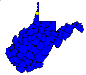
County at a Glance - Ohio 
 History1,2: Formed in 1776 from the District of West
Augusta* (Virginia) and named for the county's principal river, the Ohio,
Indian name for "great river." One of the first counties in Virginia
organized west of the Allegheny Mountains.
Area (square miles)1: 109
County Seat1: Wheeling
Population (1990)1: 50,871
Leading Industries and Chief Agricultural Products1: sheet
metal and tin containers and ware, iron and steel, coal, paints, axes and
tools, plastic products, stogies, chewing tobacco, meat packing, bakery
products, computer ribbons and toner cartridge refiller manufacturing,
custom marble tops, international food distribution, custom computers,
research and development for advanced software technology, laboratory for
new product development, problem solving and applied material research,
dairying, fruit, vegetables, hay and grain, poultry
Public Recreation Areas3: Bear Rocks Lakes Wildlife
Management Area
Coal Facts and Figures4

   Coal Reserve Summary
      Original Mineable Reserves = 910,000,000 tons
      Reported Production, 1883-1995 = 118,707,744 tons
      Estimated Loss = 118,707,744 tons
      Estimated Recoverable Reserves = 336,292,256 tons

   Coal Production, 1995
      Total Production = 0 tons
      Number of Underground Mines = 0
      Number of Surface Mines = 3


Gas and Oil Facts and Figures5

   NOTE THAT THE FOLLOWING DATA ARE PRELIMINARY VALUES--
   NOT ALL 1995 DATA HAVE BEEN REPORTED AND
   NOT ALL 1995 DATA HAVE BEEN QUALITY CHECKED.

   Gas Production, 1995
      Total Reported Production = 120 thousand cubic feet (Mcf)
      Well Count = 2
      Average Production = 60.0 Mcf

   Oil Production, 1995
      Total Reported Production = 0 barrels (bbl)
      Well Count = 0
      Average Production = 0 bbl
1 Information Source = Counties in West Virginia Blue Book - 1995:
D. E. Holmes (ed.), Chapman Printing, vol. 77, p. 731-846.
2 Information Source = New Descriptive Atlas of West Virginia: 1933,
Clarksburg Publishing Company, 64 p.
3 Information Source = Departmental, Statistical, and General
Information in West Virginia Blue Book - 1995:
D. E. Holmes (ed.), Chapman Printing, vol. 77, p. 953-1038.
4 Information Source = Statistical Section in Annual Report
and Directory of Mines - 1995, West Virginia Office of
Miners' Health, Safety, and Training, July 1996, p. 23-66. [Note: Original
Mineable Reserves from the West Virginia Geological and Economic Survey (WVGES)]
5 Information Source = West Virginia Department of Environmental Protection (WVDEP); data have undergone a cursory quality check by the WVGES
* The District of West Augusta originally included all of the lands of old
Virginia from the Blue Ridge west with the southern boundary of that state to
the Mississippi River, embracing much of the territory that now comprises the
southwestern part of Pennsylvania and most of the states of Ohio, Indiana, and
Illinois. From the original territory, eighteen or more counties in West
Virginia and three in Pennsylvania have been carved.


 Page last revised: December 5, 2005
Please send questions, comments, and/or suggestions to webmaster.
Page created and maintained by:
            West Virginia Geological and Economic Survey
  Address:  Mont Chateau Research Center
            1 Mont Chateau Road
            Morgantown, WV  26508-8079
Telephone:  304-594-2331
      FAX:  304-594-2575
    Hours:  8:00 a.m. - 5:00 p.m. EST, Monday - Friday
Permission to reproduce this material is granted if acknowledgment is given
to the West Virginia Geological and Economic Survey.


