West Virginia Geology and the WVGES Geosciences Program
The Geosciences Program covers West Virginia geologic mapping, earth-science education, geological hazards (including earthquakes), geochemistry, non-fuels mineral resources, and many other topics. Please scroll down the page or click the links above to find broad topics relating to the geology of our state and details of the work we perform. We have a page of
Frequently Asked Questions you may find interesting.
Historical Geology of West Virginia
Sea levels rising and falling, continents colliding, mountains being created, mountains being eroded away, and swamps forming coal. All of these things and more are part of West Virginia's geologic history. Please see the
historical geology of West Virginia page for more information.
Physiographic Provinces
West Virginia mainly has two major
physiographic provinces, the Appalachian (Allegheny) Plateau and the Valley and Ridge, along with a very small portion of a third province, the Blue Ridge Physiographic Province. Most of West Virginia is a dissected, generally westward-dipping plateau called the
Appalachian Plateau Physiographhic Province. The northeast portion of this province contains the
Allegheny Mountain Subprovince, or Allegheny Highlands, combining elements of the folded mountains to the east and the dissected plateau to the west. The Appalachian Plateau comprises the western two-thirds of the state and is characterized by relatively flat-lying to gently folded rocks containing extractable coal and petroleum. The eastern third of the state consists of folded and faulted rocks with no minable coal and little extractable petroleum. The eastern boundary of the Appalachian Plateau, the
Allegheny Structural Front, is a prominent geological feature trending northeast to southwest across the state. East of the Allegheny Front are a series of long folded mountains and valleys defining the Valley and Ridge Province. In the eastern panhandle, the Valley and Ridge Province contains the Great Valley Subprovince. Go to
the Physiographic Provinces page to learn more.
General Stratigraphy and Structural Geology of West Virginia
Most of the rocks exposed at the surface in West Virginia are sedimentary, deposited during the Paleozoic Era (approximately 540 to 250 million years ago). West Virginia's generalized stratigraphy is shown here in the
General Stratigraphic Column for West Virginia. Rock units exposed at the surface becomes progressively younger from east to west across the state. The oldest rocks exposed at the surface in the state are the very late Precambrian Catoctin Formation, a metamorphosed lava deposited 800 million years old, found in the eastern tip of the eastern panhandle near Haper's Ferry. The youngest sedimentary rocks exposed in West Virginia are located in the northwestern portion of the state and are assigned to the Dunkard Group, which spans the Upper Pennsylvanian-Lower Permian boundary. A nearly complete section of Paleozoic strata is exposed in the state, but not in one single outcrop.
The Geologic Transect across West Virginia provides outcrop photographs and information about the geology one would see if traveling west to east (from the youngest to the oldest rocks) across West Virginia. No significant Mesozoic or Cenozoic rocks are present in West Virginia except for relatively small exposures of Jurassic (Mesozoic) and Middle Eocene (Cenozoic)
igneous intrusives in Pendleton and Pocahontas counties, located in the east-central portion of the state near Virginia. Cenozioc alluvium is found in larger stream valleys and Cenozoic
glacial-lake deposits are found in portions of the state.
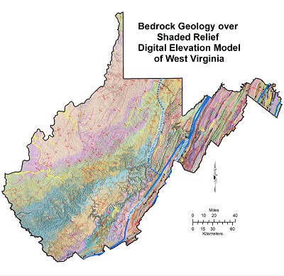
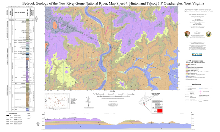
WV bedrock geology map
Movements of the earth's tectonic plates cause episodes of rifting and mountain building. Combined with subsequent erosion, production, and deposition of sediments these mountain-building episodes resulted in the geology of our state. Over 5,000 feet (1,500 m) of Cambrian through Ordovician limestones and dolostones (carbonates) were deposited by shallow marine seas over the igneous and metamorphic Precambrian basement rocks. These units are mostly below the subsurface except in southeastern West Virginia and into Virginia where they are exposed at the surface. This series of rock strata has a major detachment at its base and behaves as a coherent structural unit cut by widely spaced large-displacement thrust faults not exposed at the surface. Several cycles of alternating sandstone, shale, and carbonate units were deposited above these Cambro-Ordovician carbonates in response to tectonic loading events along the Appalachian active margin coupled with sea-level changes. The units above these Cambro-Ordovician carbonates form a separate structural package, referred to as the Martinsburg Sheet (Kulander and Dean, 1986) or the Allegheny Roof Sequence (Dunne, 1996), with tight folds and multiple internal detachments. More information on the structural geology of West Virginia can be found in Kulander and Dean (1986).
Three major deformation episodes are recognized in the Appalachians: Taconic-Ordovician/Silurian, Acadian-Devonian, and Alleghany-Carboniferous, all of which were caused by a sequence of tectonic-plate collisions that eventually led to the amalgamation of Laurentia with Gondwana. The direction of tectonic transport was consistently to the northwest. Strike-slip processes were important near the margin, but most of the major structures in West Virginia are compressional in nature. The three orogenic (mountain-building) episodes resulted in rapid subsidence events. The histical geology of West Virginia is dicussed in greater detail in the
historical geology page.

Generalized Folds and Faults of WV
In the Plateau, strata are almost horizontal at the surface, being disturbed only by widely spaced, low amplitude folds. Occasional small-displacement thrust faults are present at depth, but overall strain in the Appalachian Plateau region is small. Just west of the Allegheny Front, the dip of the beds becomes steeper before encounteringthe Valley and Ridge Province, where the landscape has a strong structural control with the ridges defined by steeply dipping resistant strata on the flanks of long linear folds with northeast-southwest axial traces and valleys usually forming in shaley units. Much of the Valley and Ridge Province is beautiful farm country. The rocks exposed are sedimentary and range in age from Ordovician to Mississippian. They record the long subsidence history of the Appalachian Basin in response to a series of terrane accretions and collisions along the margin of Laurentia culminating with the late Paleozoic Alleghany Orogeny which created most of the structures we see in the Valley and Ridge Province today.
Geologic Mapping
Some of most important products a geological survey can provide are bedrock geologic maps. Geologic mapping at WVGES includes the direct acquisition of new geological information through field reconnaissance, examination of new high-resolution digital imagery, and geochemical analysis of rock samples, in addition to the compilation of new and legacy data into digital format. Geological assessment of the area that became West Virginia began in the mid to late 1700s and early 1800s. The first comprehensive geological study was conducted by William Barton Roger, State Geologist of Virginia, from 1835 to 1841. When the West Virginia Geological and Economic Survey was established in 1897, Israel Charles White initiated a program to map the geology of the entire state, county by county, at a scale of one inch equals one mile. From 1906 to 1939 this program provided maps and reports, known as
County Geologic Reports, for all of the counties in the state. They are still used today. Scanned copies of the
County Geologic Reports are available on the
WVGES Publications web page.
WVGES is continuously refining these early 18th-century maps with greater detail and modern base imagery. We are adding data from better-defined
coal measures, ongoing subsurface assessments, paleontological studies,
oil and gas exploration,
geothermal assessments, and mineral-resource extraction. See the status of all of our
bedrock mapping here.
The WVGES Geosciences Program is presently mapping the state's bedrock geology at a 1:24,000 scale. Currently, this mapping is performed in conjunction with the
STATEMAP Program administered by the United States Geological Survey
(USGS). Details on West Virginia's STATEMAP
products are here. In addition to STATEMAP and other mapping, WVGES mapped the bedrock of the Gauley River, New River, and Bluestone River parks with a grant from the National Park Service
(NPS). Find out more on the
WVGES' Park Service mapping page.
The Geologic Transect across West Virginia provides outcrop photographs and information about the geology traveling west to east (from the youngest to the oldest rocks) across West Virginia.
Geoscience Education
Geoscience lessons for K-12 teachers were developed by WVGES staff, WVU professors, and the teachers themselves as part of the experiential 'RockCamp' Program. The WVGES
Geoscience Education web site is a huge *free* resource and includes hundreds of interactive PowerPoint presentations, PDFs, quizzes, images, and other information teachers can use to teach earth science in their classroom.
Environmental Geology and Geologic Hazards
Seismic Activity in West Virginia
While they are not as large as in other parts of the United States and the world, West Virginia does occasionally have earthquakes.
Seismic stations across West Virginia record data from ground movements and transmits those data to WVGES and USGS. Learn more about
Earthquakes and Seismicity in West Virginia.
WVGES and Water Studies
Our
Interactive Springs Database is based on our
Springs of West Virginia publication.
WVGES studies mine pools as a potential water source. A two-year cooperative-research study looking at mine-void volumes found mines having the potential to store large quantities of groundwater. The study provided an initial attempt to locate all of the large mine pools in West Virginia stratigraphically and geographically and to estimate their potential volumes based. The results of the study are included in the
Mine Pool Atlas.
Landslides
Landslides pose a threat to property and lives.
Landslide Maps are here.
Karst Potential
Karst terrain is a landscape formed primarily by the dissolution of soluble rock, such as limestone or dolostone, and is characterized by sinkholes, sinking streams, closed depressions, subterranean drainage, and caves. WVGES constructed a
generalized karst-potential map for the state based on published cave locations and broad carbonate rock (limestone and dolostone) outcrops.
Other Hazards
Click here to go to the
Homeowners' Guide to Geologic Hazards.
Geothermal Energy Potential in West Virginia
West Virginia is located on a
geothermal hot spot, and WVGES is participating in a U.S. Department of Energy-sponsored project, the
Feasibility of Deep Direct Use Geothermal on the West Virginia University Campus - Morgantown, WV, to assess the possibility of replacing an existing, conventional steam-generation power plant with one using geothermal formation water derived from a deep reservoir below the WVU campus in Morgantown. Our
Geothermal web site has much more information on geothermal energy potential in West Virginia and on this WVU geothermal project. Our interactive
Geothermal Map of West Virginia shows temperatures and other information, and our geothermal web services
(geothermal REST) page, has links to the data used in the interactive geothermal map. (Shapefiles are available upon request.)
Legacy Web Pages (to be updated)
Legacy Articles (currently being updated):
Non-Fuel Mineral Resources
Page last revised January 20, 2022.


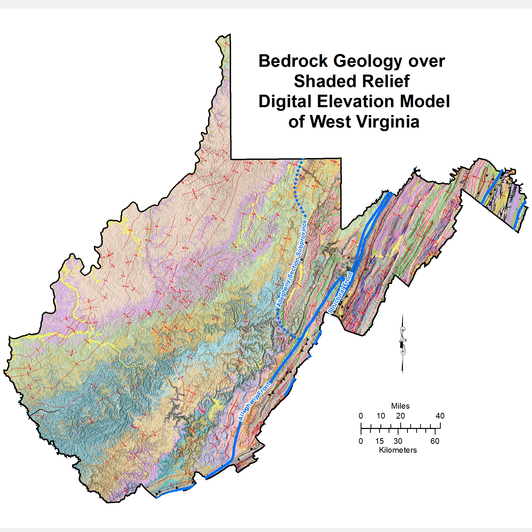 WV bedrock geology map