
West Virginia Geology:
Feature Article
 In order to display the broad scope and variety of the Mountain State's
geology, from time to time the West Virginia Geological and Economic Survey
(WVGES) showcases articles from professional geologists not directly affiliated
with the WVGES.
The Smoke Hole Region
In order to display the broad scope and variety of the Mountain State's
geology, from time to time the West Virginia Geological and Economic Survey
(WVGES) showcases articles from professional geologists not directly affiliated
with the WVGES.
The Smoke Hole Region
of
West Virginia
by
Roy S. Sites
(Biographical Sketch)
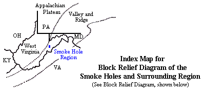
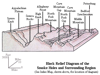
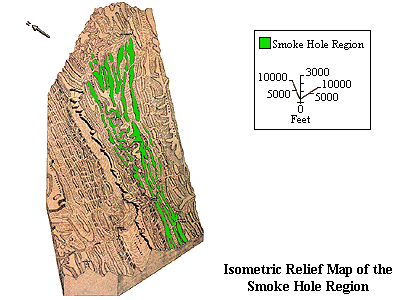
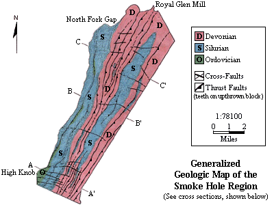
The Smoke Hole region (locally known as the Smoke Holes) represents
approximately 40-square miles of the Spruce Knob-Seneca Rocks National
Recreational Area within the Monongahela National Forest. This area is a
somewhat isolated, inaccessible, rugged mountainous-canyon region in Grant
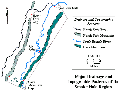
and Pendleton counties. Cave Mountain is the topographic and structural
backbone of the Smoke Holes. The Smoke Holes are dissected by the pirated
South Branch of the Potomac River, which flows north-northeastward through a
narrow gorge for the entire length of the region, thus the term Smoke Hole
Canyon or Smoke Hole Gorge. North Fork Mountain and Middle Mountain are the
two prominent topographic features that form, respectively, the western and
eastern boundaries of the Smoke Holes.
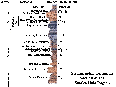
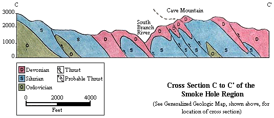
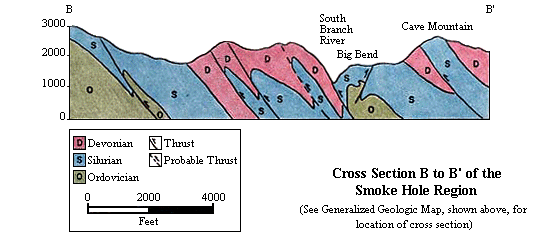
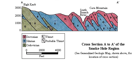
The geology of the Smoke Holes is dominated by the Cave Mountain anticline.
The stratigraphic column exposed in this region contains Lower Silurian to
Middle Devonian sandstones, limestones, and shales. This package of rocks
is bounded on the lower and upper ends by two fairly competent sandstones: the
Silurian Tuscarora and the Devonian Oriskany, respectively. The anticline
trends N 34 degrees E, and is faulted along the southeast-dipping Cave
Mountain thrust against the southeast limb of the Wills Mountain anticline (North Fork
Mountain). The Cave Mountain anticline is asymmetric to the northwest with a
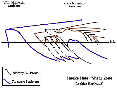
slightly overturned northwest limb. Adjacent to this northwest limb is a
highly folded and faulted zone that is representative of the designated Blue
Rock synclinal "shear zone" complex of macroscale structures between the Cave
Mountain and the Wills Mountain anticlines. Furthermore, the Cave Mountain
anticline is a doubly-plunging fold showing a culmination at the Lower
Silurian strata level near Big Bend in the center of the Smoke Holes. The
anticline appears to divide into several plunging folds upsection, at the
Lower Devonian strata level, toward each end of the fold. Particularly
noticeable are the numerous plunging anticlinal noses at the northeastern end
of the Smoke Holes.
The Cave Mountain anticline consists of subparallel northeast-trending
folds and southeast-dipping thrust faults with a maximum stratigraphic
displacement of approximately 1900 feet, throwing Lower Silurian rocks
against Lower Devonian rocks. The Cave Mountain anticline is further
structurally bounded to the northeast and southwest by major cross-strike
structural discontinuities: the nearly east-west trending Petersburg lineament
and an extension of the northwest-southeast trending Parsons lineament,
respectively.
Overall, this region reveals the interior of this thrusted
anticlinal-synclinal structure and presents a phenonmenal exposure of complex
central Appalachian macroscale structures involving the Silurian-Devonian
package of rocks. Geologically, the Smoke Holes are the most uniquely exposed
region within the westernmost central Appalachians and they have
served as a surface model for complex subsurface structures shown and/or
suspected by seismic and exploratory drilling. Furthermore, this region
provides detailed insight into the lowermost roof-sequence cover above the
suspected duplex of Cambrian-Ordovician horse-blocks and blind-thrusts at
depth.
Larger Version of the Isometric Relief Map (197K GIF, 485 pixels wide x 698 pixels high)
To view cross sections of geologic map
click reference line area, or simply scroll down to desired map
 Go to Geologic Map
 Go to Geologic Map
 Go to Geologic Map
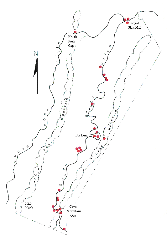
MAP OF SMOKE HOLE REGION
click on red dots to see photographs or diagrams of the area
suggested viewing from south (bottom) to north (top)
or select from a pulldown menu
or select from a list
Further Reading
- Fold Development in the Cover Enveloping the Broadtop
Horse:
- G.W. Adamson, 1992, 120 p., M.S. Thesis, West Virginia University.
- Geology of the Smoke Hole Region in Grant and Pendleton Counties,
West Virginia:
- R.S. Sites, 1971, v. 1 and 2, 106 p., M.S. Thesis, West Virginia
University.
- Geology of the Smoke Hole Region of West Virginia:
- R.S. Sites, 1973, v. 15, p. 153-167, Southeastern Geology.
- Mineral and Grant Counties:
- D.B. Reger and R.C. Tucker, 1924, 866 p., includes maps, West Virginia
Geological and Economic Survey County Geologic Report.
- Pendleton County Geological Report:
- J.L. Tilton, W.F. Prouty, and P.H. Price, 1927, 384 p., includes maps, West
Virginia Geological Survey.
- The Role of Macroscale Thrusts in the Deformation of the
Alleghanian Roof Sequence in the Central Appalachians: A Re-evaluation:
- W.M. Dunne, 1996, v. 296, p. 549-575, American Journal of Science.
- Structural Analysis of the Petersburg Lineament, Central
Appalachians:
- R.S. Sites, 1978, 273 p., Ph.D. Dissertation, West Virginia University.
- Structural Analysis of the Silurian-Devonian Cover in the Smoke
Holes, West Virginia:
- S.S. Gerritsen, 1988, 196 p., M.S. Thesis, West Virginia University.
- The Structural Development and Deformation of the Allegheny Frontal
Zone and Wills Mountain Anticlinorium - The Central Eastern Overthrust
Belt:
- R.A. Drabish and R.S. Sites, 1982, 108 p., Appalachian Geological Society
Fifthieth Anniversary Field Trip Guidebook.
- The Structural Development of the Nittany Anticlinorium in
Pendleton County, West Virginia:
- W.J. Perry, Jr., 1971, 227 p., Ph.D. Dissertation, Yale University.
- The Wills Mountain Anticline: A Study in Complex Folding and
Faulting in Eastern West Virginia:
- W.J. Perry, Jr., 1978, 29 p., West Virginia Geological and Economic
Survey Report of Investigation RI-32.


Page last revised: November 10, 2005