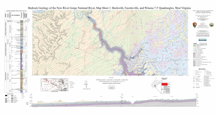
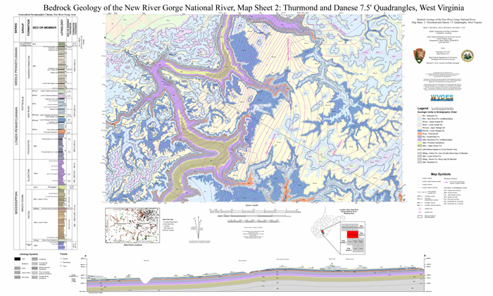
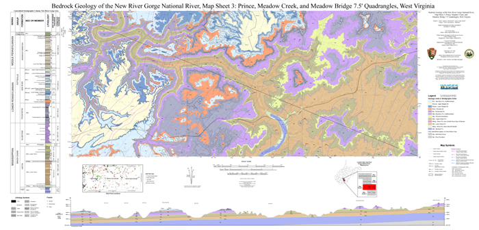
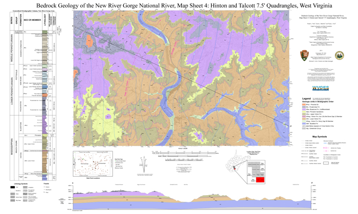
The West Virginia Geological and Economic Survey (WVGES) was contracted by the Geologic Resources Division of the National Parks Service (NPS) to map the surficial and bedrock geology of three NPS units in southern West Virginia: Bluestone National Scenic River, Gauley River National Recreation Area, and New River Gorge National River. WVGES geologists along with professors and students from Concord University and West Virginia University are producing digital surficial and bedrock geologic maps and geodatabases. Bedrock geology is being mapped for the three park units and the fourteen United States Geological Survey (USGS) 7½-minute topographic quadrangles they are contained within. Surficial geology will be mapped solely within the park boundaries of the three park units. This project will provide NPS with the necessary geologic information to help make scientifically sound resource management decisions. The areas surrounding these park units are relatively accessible to the urban East Coast and Midwest and are developing rapidly. Detailed geologic mapping will also provide new geologic information to local land-use planners and developers to aid in managing future growth in the area.
Please contact Publication Sales if you have any questions about map availability. Digital data for these maps can be downloaded from the National Park Service web site for FREE. Please see the links below each map description for the National Park Service's PDF, GIS database, KMZ/KML (Google Earth), and ArcGIS REST services.
Paula J. Hunt, Keri L. Wilson, Jane S. McColloch, and Gayle H. McColloch
Digital Cartography and Map Compilation by Sarah E. Gooding
West Virginia Geological and Economic Survey
2010
Publication OF-1001
This map and geodatabase of the bedrock geology in and around the National Park Service's Gauley River National Recreation Area covers the Ansted and Summersville Dam 7½-minute United States Geological Survey topographic quadrangles in Nicholas and Fayette counties, West Virginia. This area is located in the relatively horizontal to gently folded rocks of the Appalachian Plateau physiographic province. The Meadow and Gauley Rivers have exposed massive sandstone cliffs in their valley walls. Rock units exposed at the surface in the map area are assigned to the Lower Pennsylvanian New River Formation, Lower and Middle Pennsylvanian Kanawha Formation, and the Middle Pennsylvanian Allegheny Formation. Bedrock consists of interbedded sandstones, siltstones, shales, and coals. Carnifex Ferry State Park and the Army Corps. of Engineers' Summersville Lake and Dam are also located in the map area.
J. Steven Kite, West Virginia University
Digital Cartography and Map Compilation by Samantha J. McCreery and Sarah E. Gooding,
West Virginia Geological and Economic Survey
2016
Publication OF-1601
This map and geodatabase show the surficial geology within the park boundary of the National Park Service's Gauley River National Recreation Area in Nicholas and Fayette counties, West Virginia.


Gayle H. McColloch, Paula J. Hunt, Jane S. McColloch, Robert L. Peck; Bascombe Mitch Blake, Jr., and David L. Matchen
Digital Cartography and Map Compilation by Sarah E. Gooding
West Virginia Geological and Economic Survey
2013
Publication OF-1301
These maps, geodatabases, and the accompanying 36-page report on the bedrock geology in and around the National Park Service's New River Gorge National River covers the Beckwith, Fayetteville, Winona, Thurmond, Danese, Prince, Meadow Creek, Meadow Bridge, Hinton, and Talcott 7½-minute United States Geological Survey topographic quadrangles in Fayette, Raleigh, and Summers counties, West Virginia. Four West Virginia State Parks (Hawks Nest, Babcock, Bluestone, Little Beaver), the Army Corps. of Engineers' Bluestone Lake and Dam, and a portion of the Boy Scouts of America's Summit Bechtel Reserve are located in the project area.
Marla K. Yates and J. S. Kite, West Virginia University
Digital Cartography and Map Compilation by Sarah E. Gooding,
West Virginia Geological and Economic Survey
2015
Publication OF-1501
This map and geodatabase show the surficial geology within the park boundary of the National Park Service's New River Gorge National River in Fayette, Raleigh, and Summers counties, West Virginia. Four West Virginia State Parks (Hawks Nest, Babcock, Bluestone, Little Beaver) and the Army Corps. of Engineers' Bluestone Lake and Dam are located in the project area.
David L. Matchen, Joseph L. Allen, Robert L. Peck, and David Mercier
Concord University
Digital Cartography and Map Compilation by Sarah E. Gooding and Paula J. Hunt
West Virginia Geological and Economic Survey
2011
Publication OF-1101
This map of the bedrock geology in and around the National Park Service's Bluestone National Scenic River covers the Flat Top and Pipestem 7½-minute United States Geological Survey topographic quadrangles in Summers, Mercer, and Raleigh counties, West Virginia. The spectacular scenery of the Bluestone River Gorge is the result of erosion through the Princeton and Glady Fork Sandstones. Bluestone State Park, Pipestem Resort State Park, and a portion of Camp Creek State Park are also located in the map area.
Marla K. Yates and J. S. Kite, West Virginia University
Digital Cartography and Map Compilation by Sarah E. Gooding,
West Virginia Geological and Economic Survey
2014
Publication OF-1401
This map and geodatabase show the surficial geology within the park boundary of the National Park Service's Bluestone National Scenic River Area in Summers and Mercer counties, West Virginia.
 WV Geological & Economic Survey