Physiographic Provinces of West Virginia
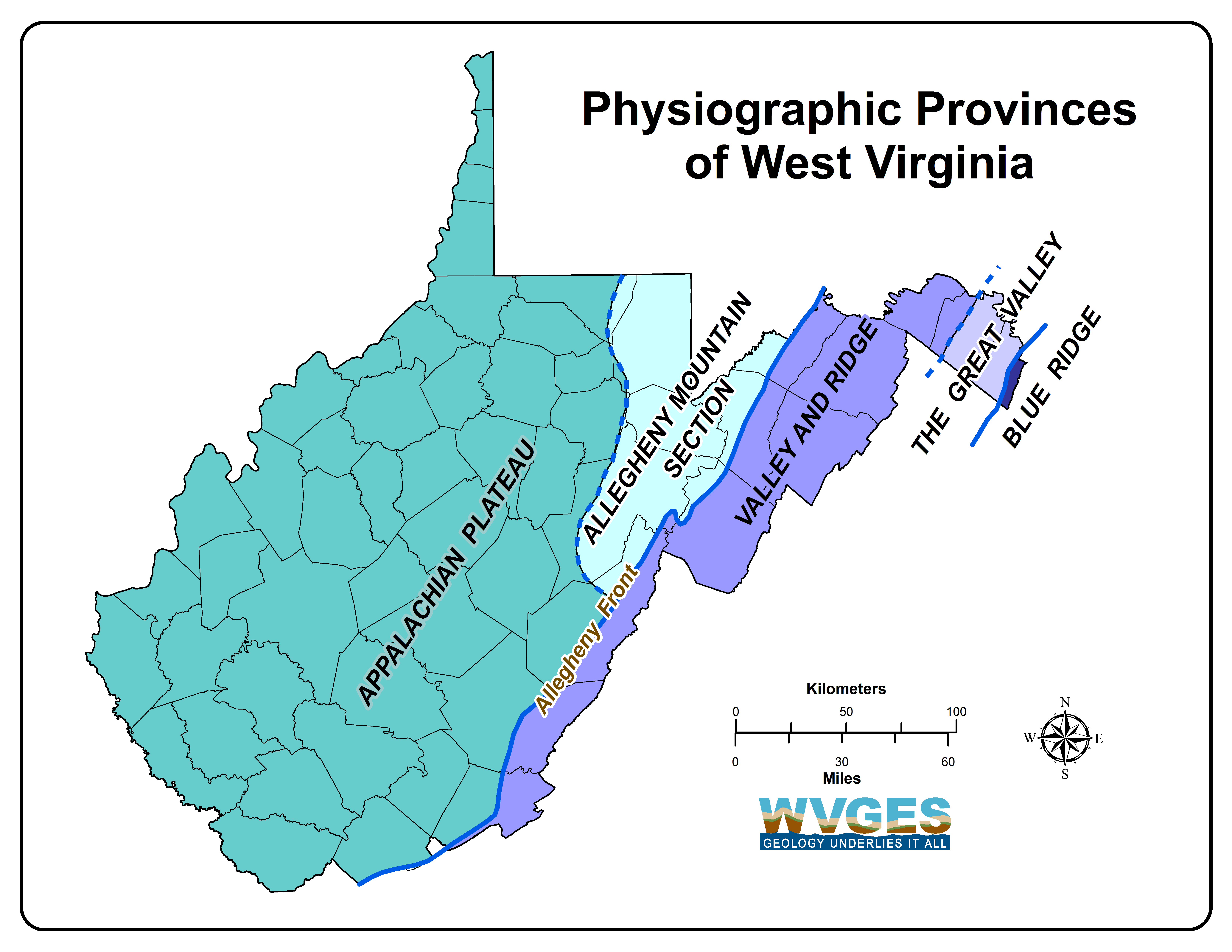
The processes that shaped West Virginia are discussed in the the historical geology page. West Virginia mainly has two major physiographic provinces, the Appalachian (Allegheny) Plateau and the Valley and Ridge, along with a very small portion of a third province, the Blue Ridge Physiographic Province. Most of West Virginia is a dissected, generally westward-dipping plateau called the Appalachian Plateau Physiographic Province. The northeast portion of this province contains the Allegheny Mountain Subprovince, or Allegheny Highlands, combining elements of the folded mountains to the east and the dissected plateau to the west. The Appalachian Plateau comprises the western two-thirds of the state and is characterized by relatively flat-lying to gently folded rocks containing extractable coal and petroleum. The eastern third of the state consists of folded and faulted rocks with no minable coal and little extractable petroleum. The eastern boundary of the Appalachian Plateau, the Allegheny Structural Front, is a prominent geological feature trending northeast to southwest across the state. East of the Allegheny Front are a series of long folded mountains and valleys defining the Valley and Ridge Province. In the eastern panhandle, the Valley and Ridge Province contains the Great Valley Subprovince.
The oldest rocks in the state are located in the easternmost portion of the eastern panhandle, and as one proceeds westward, the rocks are younger and younger (see general geology discussion). More specifically, the oldest rocks in the east are very late Precambrian (the Catoctin Formation) and then a nearly complete section of the Paleozoic is exposed moving to the west. No significant Mesozoic or Cenozoic rocks are present in West Virginia except for relatively small exposures of Jurassic (Mesozoic) and Middle Eocene (Cenozoic) igneous intrusives in Pendleton and Pocahontas counties, located in the east-central portion of the state near Virginia. Cenozioc alluvium is found in larger stream valleys and Cenozoic glacial-lake deposits are found in portions of the state. Please see the WV glaciation page for more information on the effects of glaciation on West Virginia.

Lidar hillshade showing the folded Valley and Ridge Provence next to the less folded Appalachian (Allegheny) Plateau Province, WV
The late Precambrian Catoctin Formation is in the Blue Ridge Physiographic Province. We only have limited outcrops of the Blue Ridge here in West Virginia, and those are in the very eastern part of our state near Harper's Ferry. Rocks of the Blue Ridge are better exposed across the border in Virginia.
The Valley and Ridge Physiographic Province in the east contains folded and faulted rocks ranging in age from late Precambrian to early Mississippian. West of the Blue Ridge Mountains is the Great Valley Subprovince of the Valley and Ridge Province. This relatively flat, agriculturally rich region is composed of complexly folded and faulted Cambrian and Ordovician limestone and dolostone with one prominent Ordovician shale (the Martinsburg Shale). The Great Valley ends at North Mountain and from there to the Allegheny Front, a distance of about 50 miles, are a series of northeast-trending mountains and valleys. The rocks in this part of the Valley and Ridge range in age from late Ordovician to early Mississippian. The valleys are primarily composed of less-resistant shale and siltstone, while the mountain ridges are mainly resistant sandstone and limestone. The structural geology of the Valley and Ridge is complex with extensive thrust faults and folds that contribute to the repetition of all the rock formations. In addition, three major allochthonous thrust sheets have displaced the surface and subsurface rocks westward in the order of 30 to 50 miles. Please refer to the general geology page for more information on the structural geology of West Virginia.

Lidar hillshade showing the New River Gorge in the dissected Appalachian (Allegheny) Plateau Physiographic Province, WV
The boundary between the Valley and Ridge and Appalachian Plateau physiographic provinces, the Allegheny Front, marks a relatively abrupt change in topography, stratigraphy, and structure. This boundary in the eastern part of the state runs northeast to southwest, parallel to the general strike of the rock units.
The Appalachian Plateau Physiographic Province covers the western two-thirds of the State where the rock units are relatively flat to gently folded. Folding and faulting increases on the eastern edge of the province near the Valley and Ridge, and the Allegheny Mountain Subprovince, or Allegheny Highlands Section, has properties of both the relatively flat-lying, dissected Plateau and the folded and faulted Valley and Ridge. The majority of the Appalachian Plateau is Pennsylvanian and Permian strata and this province contains the majority of the minable coal and extractable petroleum in the state. The rocks exposed in the northern part of the Plateau are younger than those exposed in the southern part. This is also reflected in the age of the minable coal beds: younger in the north and older in the south.

Physiographic Provinces of West Virginia draped over Elevation Hillshade