Heat is generated within the Earth. Generally, the deeper the hotter, with the core of the Earth being as hot as the sun's surface (U.S. Energy Information Administration,
Geothermal Explained). This heat makes its way close to the Earth's surface in some places, as with the thermal springs in Appalachia, the Old Faithful Geyser at Yellowstone National Park, the spreading center at Iceland, and many other examples. Harnessing this heat and using it to warm us and generate electricity is a hot topic (pun intended) of research in the United States, as discussed by the U.S. Department of Energy's Office of Energy Efficiency and Renewable Energy on its
Geothermal Basics web page. The Department of Energy is specifically looking at
Enhanced Geothermal Systems and
Hydrothermal Resources, as well as
Low-Temperature and Coproduced Resources.
Geothermal Energy in West Virginia
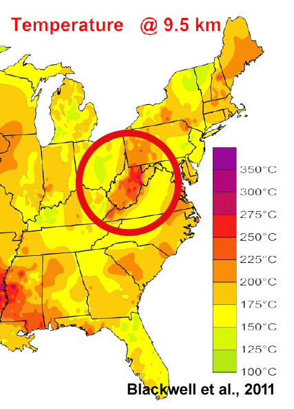
Researchers at Southern Methodist University's Geothermal Laboratory received a grant from Google.org to update their
Geothermal Map of North America. Their
results for West Virginia show the Mountain State is a relative hot spot in the Eastern U.S. and has subsurface temperatures high enough for geothermal energy generation on a commercial scale. The findings are detailed in the report: Blackwell, David, Richards, Maria, Frone, Zachary, Batir, Joe, Ruzo, Andrés, Dingwall, Ryan, and Williams, Mitchell, 2011,
Temperature-At-Depth Maps for the Conterminous U.S. and Geothermal Resource Estimates: USDOE Office of Energy Efficiency and Renewable Energy Geothermal Technologies Office, Geothermal Resources Council 2011 Annual Meeting, San Diego, CA, (United States), 24-27 Oct 2011, GRC Transactions, Vol 35,pp. 1545-1550, URL:
http://pubs.geothermal-library.org/lib/grc/1029452.pdf
The City of Morgantown is located near this
West Virginia geothermal hot spot (Blackwell et al., 2011), and WVGES is part of a U.S. Department of Energy-
sponsored project assessing the possibility of replacing an existing fossil-fuel-fired power plant with geothermal energy for the West Virginia University campus. At the surface, the Silurian Tuscarora Sandstone forms some of West Virginia's most impressive peaks, including the iconic Seneca Rocks in Pendleton County, where the white, super-mature, quartz sandstone is thrust almost vertically. In the subsurface, formation water in the deeply buried Tuscarora is a potential geothermal reservoir. Working with DOE in coordination with the West Virginia University Energy Institute on the
Feasibility of Deep Direct Use Geothermal on the West Virginia University Campus - Morgantown, WV project, WVGES helped investigate the geothermal potential of the Tuscarora Sandstone, located approximately 10,000 feet beneath Morgantown. As part of this assessment, WVGES geologists collected over 2,200 permeability and porosity measurements from Tuscarora cores stored in the WVGES core holdings. WVGES presented a scientific poster
discussing these measurements and their results.
The WVGES
interactive geothermal map shows preliminary geothermal maps (not based on a basin-corrected model) along with WVGES well data and other geologic and basic data. Our
Geographic Information Systems REST Service includes all of the WVGES geothermal map web services associated with the interactive geothermal map.
Reference
Blackwell, David, Richards, Maria, Frone, Zachary, Batir, Joe, Ruzo, Andrés, Dingwall, Ryan, and Williams, Mitchell, 2011, Temperature-At-Depth Maps for the Conterminous U. S. and Geothermal Resource Estimates: USDOE Office of Energy Efficiency and Renewable Energy Geothermal Technologies Office, Geothermal Resources Council 2011 Annual Meeting, San Diego, CA, (United States), 24-27 Oct 2011, GRC Transactions, Vol 35,pp. 1545-1550, URL:
http://pubs.geothermal-library.org/lib/grc/1029452.pdf


 West Virginia Is Hot Bed for Geothermal Resources: Green Energy Source in Coal Country
 PDF, 14.06 MB, 372 pages)