
STATEMAP Projects for 2001:
Snowy Mountain and Spruce Knob Quadrangles

Preliminary Bedrock Geologic Map of the Snowy Mountain Quadrangle
Publication OF-0101
Preliminary Bedrock Geologic Map of the Spruce Knob Quadrangle
Publication OF-0102
Principal Investigators: Ronald McDowell, Katharine Lee Avary, and David Matchen (WVGES)
Contributing Investigator: Rick Diecchio (George Mason University)
Geological Assistants: Hannah McCoy and Alex Rutledge (West Virginia University)
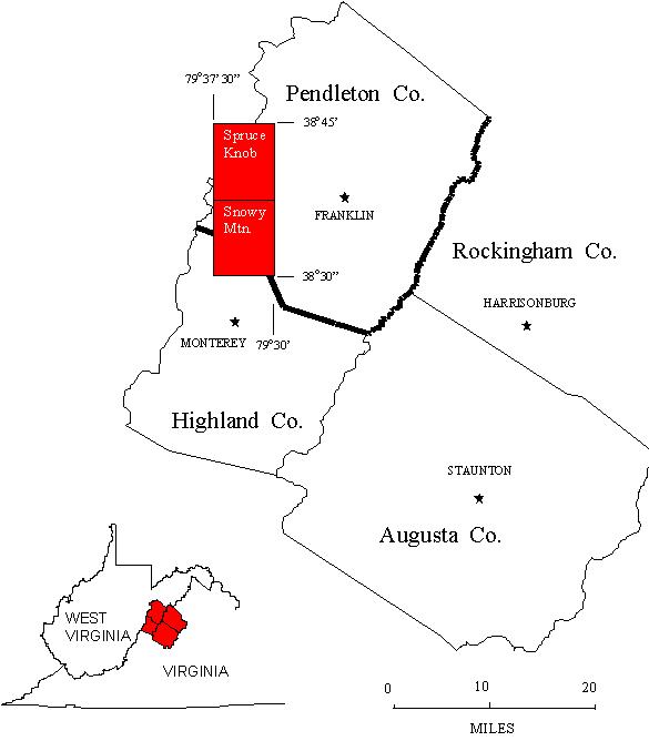 The Spruce Knob and Snowy Mountain 7 ½ Minute quadrangles are located in extreme southwestern Pendleton County, West Virginia.
The southwestern edge of the Spruce Knob quadrangle also includes small portions of Pocahontas and Randolph counties, West Virginia.
The Snowy Mountain quadrangle straddles the border of Highland County, Virginia to the south. The Spruce Knob and Snowy
Mountain quadrangles were chosen for investigation in 2001 as part of an ongoing bedrock mapping and geochemical investigation
that began with work in Pendleton County, WV in 1997 (STATEMAP). Again in 2001, we had the services
of Dr. Rick Diecchio of George Mason University, Fairfax, Virginia, as a Contributing Investigator. We were also fortunate enough to
have two well-qualified student interns for the summer. Hannah McCoy and Alex Rutledge are undergraduate geology majors
at West Virginia University and performed admirably as geological assistants in all aspects of this STATEMAP01 Mapping Project. Funding for the student interns
came indirectly from the National Science Foundation through the Association of American State Geologists with matching funds provided by
the West Virginia Geological and Economic Survey (WVGES). We were
accompanied in the field for several weeks by two very enthusiastic high school science teachers, Mary Sue Burns from Pocahontas County,West Virginia and Paula Waggy
from Pendleton County,West Virginia. The teachers gained hands-on experience in all aspects of field geology and we expect they will pass on
numerous anecdotes about how geologists really operate when doing fieldwork. Last, but not least, we wish to acknowledge very helpful
field consultations with Gerald Wilkes, Virginia Division of Mineral Resources, Charlottesville, Virginia; Phillip Martin, Consultant, Bridgeport,
West Virginia; Barrie Wolf, United States Department of Agriculture (USDA) - National Resources Conservation Service, Hot Springs, Virginia; and Dr. John Haynes, Pomfret School, Pomfret, Connecticut.
The Spruce Knob and Snowy Mountain 7 ½ Minute quadrangles are located in extreme southwestern Pendleton County, West Virginia.
The southwestern edge of the Spruce Knob quadrangle also includes small portions of Pocahontas and Randolph counties, West Virginia.
The Snowy Mountain quadrangle straddles the border of Highland County, Virginia to the south. The Spruce Knob and Snowy
Mountain quadrangles were chosen for investigation in 2001 as part of an ongoing bedrock mapping and geochemical investigation
that began with work in Pendleton County, WV in 1997 (STATEMAP). Again in 2001, we had the services
of Dr. Rick Diecchio of George Mason University, Fairfax, Virginia, as a Contributing Investigator. We were also fortunate enough to
have two well-qualified student interns for the summer. Hannah McCoy and Alex Rutledge are undergraduate geology majors
at West Virginia University and performed admirably as geological assistants in all aspects of this STATEMAP01 Mapping Project. Funding for the student interns
came indirectly from the National Science Foundation through the Association of American State Geologists with matching funds provided by
the West Virginia Geological and Economic Survey (WVGES). We were
accompanied in the field for several weeks by two very enthusiastic high school science teachers, Mary Sue Burns from Pocahontas County,West Virginia and Paula Waggy
from Pendleton County,West Virginia. The teachers gained hands-on experience in all aspects of field geology and we expect they will pass on
numerous anecdotes about how geologists really operate when doing fieldwork. Last, but not least, we wish to acknowledge very helpful
field consultations with Gerald Wilkes, Virginia Division of Mineral Resources, Charlottesville, Virginia; Phillip Martin, Consultant, Bridgeport,
West Virginia; Barrie Wolf, United States Department of Agriculture (USDA) - National Resources Conservation Service, Hot Springs, Virginia; and Dr. John Haynes, Pomfret School, Pomfret, Connecticut.
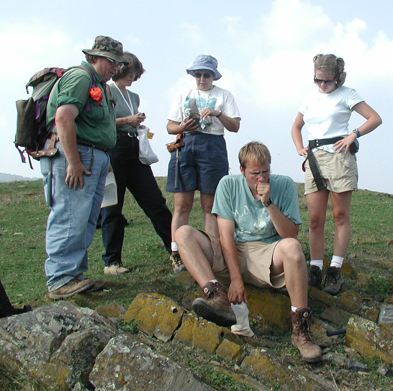 Part of the geological field crew for STATEMAP01 examining and bagging igneous rock samples. From left to right - Ron McDowell,
Mary Sue Burns, Paula Waggy, and Hanna McCoy. Foreground: Alex Rutledge.
Part of the geological field crew for STATEMAP01 examining and bagging igneous rock samples. From left to right - Ron McDowell,
Mary Sue Burns, Paula Waggy, and Hanna McCoy. Foreground: Alex Rutledge.
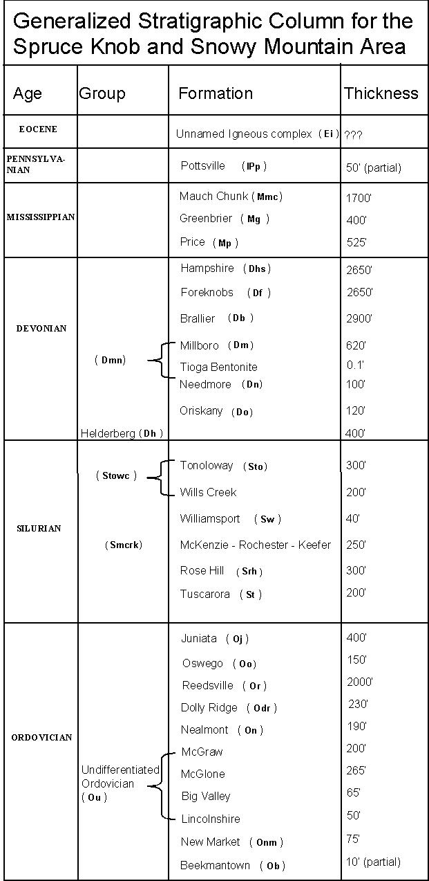 Rock units in the Snowy Mountain and Spruce Knob area range in age from Ordovician through Eocene. Shown above is a chart of the
stratigraphic units encountered in the mapping area.
Rock units in the Snowy Mountain and Spruce Knob area range in age from Ordovician through Eocene. Shown above is a chart of the
stratigraphic units encountered in the mapping area.
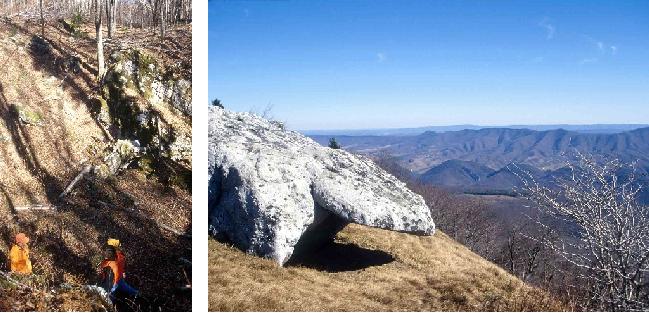 In general, rock units in the Snowy Mountain and Spruce Knob quads get younger to the west as one goes from the Ordovician, Silurian,
and Devonian rocks of the Valley and Ridge physiographic province across the Allegheny Front into the Devonian, Mississippian, and
Pennsylvanian rocks of the Appalachian Plateau. Shown above are two photographs taken on the Spruce Knob quad. On the
left is the view looking into a large sinkhole developed in the Mississippian Greenbrier Limestone. On the right is the view looking east
from Spruce Knob. The rock exposed in the foreground is the Pennsylvanian Pottsville Sandstone; to the east, one can see the River Hills,
North Fork Mountain, and, in the distance, Shenandoah Mountain.
In general, rock units in the Snowy Mountain and Spruce Knob quads get younger to the west as one goes from the Ordovician, Silurian,
and Devonian rocks of the Valley and Ridge physiographic province across the Allegheny Front into the Devonian, Mississippian, and
Pennsylvanian rocks of the Appalachian Plateau. Shown above are two photographs taken on the Spruce Knob quad. On the
left is the view looking into a large sinkhole developed in the Mississippian Greenbrier Limestone. On the right is the view looking east
from Spruce Knob. The rock exposed in the foreground is the Pennsylvanian Pottsville Sandstone; to the east, one can see the River Hills,
North Fork Mountain, and, in the distance, Shenandoah Mountain.
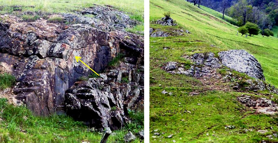 An exception to structural and stratigraphic trends along the Allegheny Front is the single Eocene dike visible along Snowy Mountain Road,
approximately one mile due east of Snowy Mountain. We believe that this shallow igneous intrusive is related to other Eocene igneous bodies
found within the Pendleton County, West Virginia - Highland County, Virginia border region. Shown above is a photograph of the diabase dike
that crops out on both sides of the road. An arrow points to poorly developed columnar or polygonal jointing along the upper margins of the
dike north of the road. This type of jointing forms when a molten igneous body cools more quickly at its margins than in the center. The
photograph on the right shows the continuation of the dike south of Snowy Mountain Road.
An exception to structural and stratigraphic trends along the Allegheny Front is the single Eocene dike visible along Snowy Mountain Road,
approximately one mile due east of Snowy Mountain. We believe that this shallow igneous intrusive is related to other Eocene igneous bodies
found within the Pendleton County, West Virginia - Highland County, Virginia border region. Shown above is a photograph of the diabase dike
that crops out on both sides of the road. An arrow points to poorly developed columnar or polygonal jointing along the upper margins of the
dike north of the road. This type of jointing forms when a molten igneous body cools more quickly at its margins than in the center. The
photograph on the right shows the continuation of the dike south of Snowy Mountain Road.
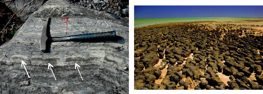 As one goes south, the exposed rocks become progressively older; the oldest rock unit in the map area, the Ordovician Beekmantown Dolomite, is exposed along the bottom of the Snowy Mountain
quad. Shown above is an example of features observed in the Beekmantown and a modern "equivalent" to help explain the significance of these features.
On the left is a cross-sectional view of a number of algal stromatolites in a boulder of Ordovician Beekmantown Dolomite from a quarry
about 5 miles south of Blue Grass, Virginia. The presence of algae in carbonate rocks is usually indicated by thin (less than 1 millimeter) layers
or laminations in the rock. These laminations are typically parallel to each other but are not always flat or continuous for more than a few
feet. The algae in this rock in some instances formed continuous layers but in others (arrows) formed isolated "colonies." These colonies
or algal heads are similar to, but smaller than, those seen today in Hamelin Pool, Shark Bay in Australia. The photograph on the right is
of Hamelin Pool at low tide. The individual algal heads in this photo are approximately 6 to 10 inches in diameter and may be over a foot
tall. Hamelin Pool is very shallow (1 or 2 feet deep) even at high tide. Because temperatures here may be close to 100° F year round,
seawater evaporates rapidly causing the salt concentration in the water to rise dramatically (water becomes hypersaline). As you can see, the
algae here are able to withstand these harsh conditions.
As one goes south, the exposed rocks become progressively older; the oldest rock unit in the map area, the Ordovician Beekmantown Dolomite, is exposed along the bottom of the Snowy Mountain
quad. Shown above is an example of features observed in the Beekmantown and a modern "equivalent" to help explain the significance of these features.
On the left is a cross-sectional view of a number of algal stromatolites in a boulder of Ordovician Beekmantown Dolomite from a quarry
about 5 miles south of Blue Grass, Virginia. The presence of algae in carbonate rocks is usually indicated by thin (less than 1 millimeter) layers
or laminations in the rock. These laminations are typically parallel to each other but are not always flat or continuous for more than a few
feet. The algae in this rock in some instances formed continuous layers but in others (arrows) formed isolated "colonies." These colonies
or algal heads are similar to, but smaller than, those seen today in Hamelin Pool, Shark Bay in Australia. The photograph on the right is
of Hamelin Pool at low tide. The individual algal heads in this photo are approximately 6 to 10 inches in diameter and may be over a foot
tall. Hamelin Pool is very shallow (1 or 2 feet deep) even at high tide. Because temperatures here may be close to 100° F year round,
seawater evaporates rapidly causing the salt concentration in the water to rise dramatically (water becomes hypersaline). As you can see, the
algae here are able to withstand these harsh conditions.
Environmental conditions during the deposition of the sediments of the Beekmantown Dolomite were probably similar. Scientists make this
conclusion based on one of the guiding ideas of geology, the Principle of Uniformitarianism: processes active today acted in a similar
fashion in the past to produce the rocks we see today. The Shark Bay stromatolite photo was borrowed from the following website:
http://www.ldeo.columbia.edu/~small/personal/AesStromatolite.html.
More information about the stromatolites at Hamelin Pool can be found at:
http://www.naturebase.net/component/option,com_hotproperty/task,view/id,56/Itemid,755/,
the official website for this Australian National Park.
The most problematic units for field recognition and mapping purposes are the Ordovician carbonates lying stratigraphically below the Ordovician Reedsville Formation. Even after several field consultations with geologists who had worked
in these carbonate rocks previously, there is still confusion among the project's staff as to the "correct" stratigraphic terminology and, more importantly, the "correct" lithologic description of several of the Ordovician units. We believe that we
have a set of operational lithologic characteristics for the Ordovician Dolly Ridge, Nealmont, New Market, and Beekmantown formations that allow us to differentiate these units in the field with a good degree of certainty. However, especially
in the Snowy Mountain area, there are additional, poorly exposed and perhaps ill-defined Ordovician carbonates lying stratigraphically between the Nealmont and New Market formations that have defied our powers of discrimination. These
units, the McGraw, McGlone, Big Valley, and Lincolnshire formations (terminology of Kay, 1956), are all Black Riverian in age except for the Lincolnshire, which is Chazyan. The argillaceous (clay-rich) nature of many of these units makes for very poor
exposure. Although each has distinctive features (for example, the black flint nodules of the Lincolnshire and the crossbedded grainstones of the McGraw), the small, isolated outcrops encountered in the map area are not sufficient for certain assignment
to formation. As a result, these formations are mapped as a single undifferentiated unit. Whether or not this situation will be clarified during STATEMAP02 mapping on the adjacent Circleville quadrangle remains to be seen.
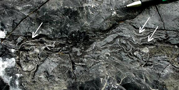 Closeup photograph of a layer of bryozoan fronds (arrows) in the Ordovician Lincolnshire Limestone, about 2 miles north of
Blue Grass, Virginia. Mechanical pencil indicates the scale.
Closeup photograph of a layer of bryozoan fronds (arrows) in the Ordovician Lincolnshire Limestone, about 2 miles north of
Blue Grass, Virginia. Mechanical pencil indicates the scale.
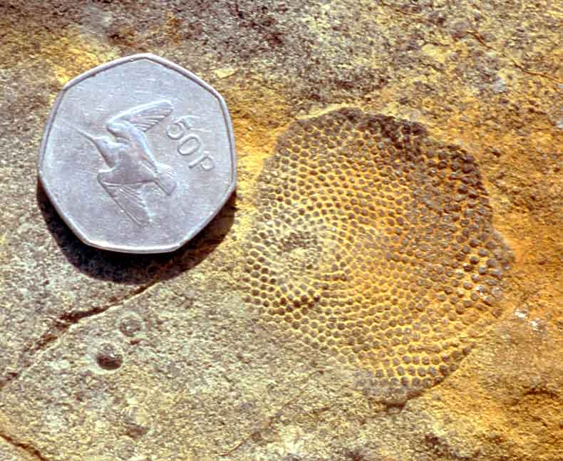 Closeup photograph of the fossil Receptaculites sp., an index fossil for the Ordovician, in the "Undifferentiated" Middle Ordovician
carbonates exposed north of Blue Grass, Virginia. This problematic fossil organism has been know since the 1800's and has been interpreted as both
calcareous algae and as a calcareous sponge. Coin is 3 cm in diameter.
Closeup photograph of the fossil Receptaculites sp., an index fossil for the Ordovician, in the "Undifferentiated" Middle Ordovician
carbonates exposed north of Blue Grass, Virginia. This problematic fossil organism has been know since the 1800's and has been interpreted as both
calcareous algae and as a calcareous sponge. Coin is 3 cm in diameter.
In general, structural deformation within the Snowy Mountain quadrangle is more extensive than in the Spruce Knob quadrangle. This is
not surprising considering that the Spruce Knob area lies primarily within the Appalachian Plateau physiographic province. Deformation
seen in exposed strata in the Spruce Knob quadrangle and western third of the Snowy Mountain quadrangle consists of gentle folding of
Devonian through Pennsylvanian sedimentary units. The southeastern corner of the Spruce Knob quadrangle and the remainder of the Snowy
Mountain quadrangle, which lie in the Valley and Ridge physiographic province, are within a much more complex deformational regime.
This deformation takes the form of multiple thrust faults, all generally trending northeast-southwest, that appear to be rooted in the
Ordovician, Silurian, and Devonian shales present in the area. These thrusts remove or thin many of the less resistant sedimentary units;
for example, the Silurian Tonoloway, Wills Creek, McKenzie, Rochester, and Keefer are only observed in the extreme southwest corner of the Snowy
Mountain quadrangle. In addition, many of the more resistant rock units such as the Silurian Tuscarora and Williamsport are observed to
be vertical or overturned. These units may be broken into isolated blocks such that as one moves along strike, adjacent blocks may have
dips that vary as much as 25º. Recumbent anticlinal folding is inferred in the Ordovician strata in the Snowy Mountain quadrangle. In
several instances, especially in close proximity to thrust faults, these strata are observed to be so tightly folded that the crests of
small, intraformational anticlines are broken and the limbs collapsed together like the folds of an accordion.
 Shown above are two examples of small-scale deformation encountered on the Snowy Mountain quadrangle. On the left is an outcrop of Devonian Brallier Formation approximately 1.5 miles south of Cherry
Grove, West Virginia. This outcrop shows folding in one of the thin sandstone beds found within the Brallier. White arrows indicate the direction of compressional stress required to deform the
sandstone in this manner. NOTE: unless confined by the weight of thousands of feet of overlying strata, brittle rocks like sandstone will normally break rather than bend when put under
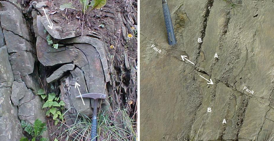
stress. Rock hammer is approximately 1 foot long. On the right is an outcrop of the Ordovician Reedsville Formation approximately 1 mile south of Hardscrabble, Virginia. At this locality,
all the rock units present have been tilted from their originally horizontal position to a point past vertical - they are overturned. This portion of the uppermost Reedsville, known as the
Orthorhynchula zone, is marked by the presence of thin layers of brachiopod (Orthorhynchula sp.) fossils from which all the original calcite shell material has been dissolved leaving a void
or mold of the exterior of the shells. Two of these layers (marked A and B) are visible in the outcrop. Also visible is the trace of a small fault with approximately 3 inches of displacement.
Above the fault (the "hanging" wall), layers A and B have been shifted upward and to the left (arrows show the sense of motion). This indicates that the fault is a reverse fault caused by compressional
stress from the right side of the photograph (east). The rock hammer's handle is approximately 8 inches long.
Shown above are two examples of small-scale deformation encountered on the Snowy Mountain quadrangle. On the left is an outcrop of Devonian Brallier Formation approximately 1.5 miles south of Cherry
Grove, West Virginia. This outcrop shows folding in one of the thin sandstone beds found within the Brallier. White arrows indicate the direction of compressional stress required to deform the
sandstone in this manner. NOTE: unless confined by the weight of thousands of feet of overlying strata, brittle rocks like sandstone will normally break rather than bend when put under
stress. Rock hammer is approximately 1 foot long. On the right is an outcrop of the Ordovician Reedsville Formation approximately 1 mile south of Hardscrabble, Virginia. At this locality,
all the rock units present have been tilted from their originally horizontal position to a point past vertical - they are overturned. This portion of the uppermost Reedsville, known as the
Orthorhynchula zone, is marked by the presence of thin layers of brachiopod (Orthorhynchula sp.) fossils from which all the original calcite shell material has been dissolved leaving a void
or mold of the exterior of the shells. Two of these layers (marked A and B) are visible in the outcrop. Also visible is the trace of a small fault with approximately 3 inches of displacement.
Above the fault (the "hanging" wall), layers A and B have been shifted upward and to the left (arrows show the sense of motion). This indicates that the fault is a reverse fault caused by compressional
stress from the right side of the photograph (east). The rock hammer's handle is approximately 8 inches long.
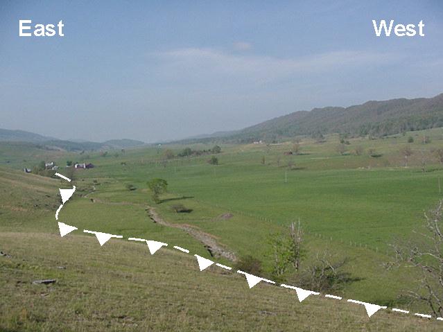 Larger scale deformation features are more subtle in the mapping area. Show above is the view looking southwest along Frank's Run towards Blue Grass, Virginia. Frank's Run follows the trace of a major thrust fault for most of its length.
The stretch of the creek shown above actually follows a "splay" or offshoot from the main fault. The white line with "bear teeth" marks the trace of this small thrust that caused older Middle Ordovician strata (termed "Undifferentiated Ordovician") on the east
side of the fault to be thrust up and on top of the Middle Ordovician Nealmont Formation. Two more thrust faults lie to the west, less than a mile away.
Larger scale deformation features are more subtle in the mapping area. Show above is the view looking southwest along Frank's Run towards Blue Grass, Virginia. Frank's Run follows the trace of a major thrust fault for most of its length.
The stretch of the creek shown above actually follows a "splay" or offshoot from the main fault. The white line with "bear teeth" marks the trace of this small thrust that caused older Middle Ordovician strata (termed "Undifferentiated Ordovician") on the east
side of the fault to be thrust up and on top of the Middle Ordovician Nealmont Formation. Two more thrust faults lie to the west, less than a mile away.
REFERENCES
Diecchio, R., Gray, K., McDowell, R., and Dennison, J., 2001, Eocene igneous activity and related phenomena, central Appalachian Valley
and Ridge: Geological Society of America Abstracts with Programs, V. 33, No. 2, p. 6, abstract.
Garnar, T., 1951, The igneous rocks of Pendleton County, West Virginia: West Virginia University, Morgantown, unpublished MS thesis, 106 p.
Garnar, T., 1956, The igneous rocks of Pendleton County, West Virginia: West Virginia Geological and Economic Survey, Report of
Investigations No. 12, 31 p.
Kay, M., 1956, Ordovician limestones in the western anticlines of the Appalachians in West Virginia and Virginia, northeast of the
New River: G. S. A. Bulletin, v. 67, p. 55-106.
McDowell, R., compiler, 2001, Stratigraphic Geochemical Database for Portions of Pendleton, County, West Virginia and Adjacent Virginia
Counties, covering portions of Pendleton Co., WV, Highland Co. VA, and Augusta Co., VA: West Virginia Geological and Economic Survey,
Report of Investigations RI-34, computer diskette.
Perry, W., 1971, The structural development of the Nittany Anticlinorium in Pendleton County, West Virginia, Yale University,
New Haven, unpublished Ph.D. thesis, 227 p.
Rutledge, F., McCoy, H, Avary, K., Matchen, D., and McDowell, R., 2002, Preliminary investigation of new exposures of Upper
Devonian strata, Elkins, West Virginia: GSA Abstracts with Programs, V. 34, No. 2, p. 86, abstract.
Southworth, C., Gray, K., and Sutter, J., 1993, Middle Eocene intrusive rocks of the central Appalachian Valley and Ridge province - setting,
chemistry, and implications for crustal structure: United States Geological Survey, Bulletin 1839-J, p. 1-24.
Tso, J., McDowell, R., Avary, K., Matchen, D., and Wilkes, G., 2004, Middle
Eocene igneous rocks in the Valley and Ridge of Virginia and West Virginia: in Southworth, S. and Burton, W., eds., Geology of the National
Capital Region - Field Trip Guidebook, U. S. G. S. Circular 1264, p. 137-161.

 Page last revised: November 15, 2005
