
STATEMAP Projects for 1997:
Palo Alto Quadrangle

Preliminary Bedrock Geologic Map of the Palo Alto Quadrangle
Publication OF-9704
Principal Investigators: Ronald McDowell, Katharine Lee Avary, and David Matchen (WVGES)
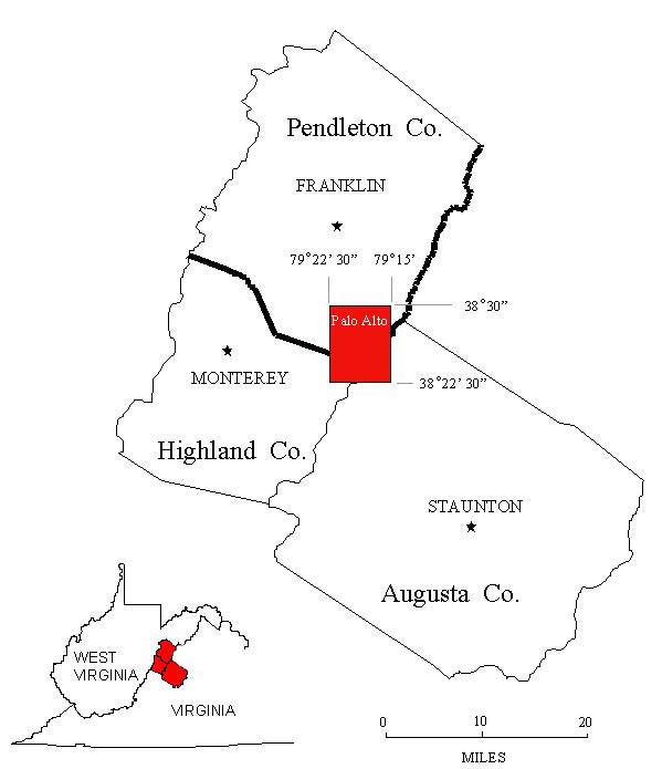 The Palo Alto 7 ½ Minute Quadrangle is located in extreme southern Pendleton County, West Virginia and straddles the
borders of Highland County, Virginia and Augusta County, Virginia to the south. The Palo Alto quadrangle was chosen for
investigation in 1997 as the initial phase of a bedrock mapping and geochemical investigation of some of the youngest and most
unusual rocks in the State of West Virginia, Middle Eocene--mafic and feldspathic, igneous rocks (Garnar, 1951 and 1956;
Southworth and others, 1993; Tso and others, 2004).
The Palo Alto 7 ½ Minute Quadrangle is located in extreme southern Pendleton County, West Virginia and straddles the
borders of Highland County, Virginia and Augusta County, Virginia to the south. The Palo Alto quadrangle was chosen for
investigation in 1997 as the initial phase of a bedrock mapping and geochemical investigation of some of the youngest and most
unusual rocks in the State of West Virginia, Middle Eocene--mafic and feldspathic, igneous rocks (Garnar, 1951 and 1956;
Southworth and others, 1993; Tso and others, 2004).
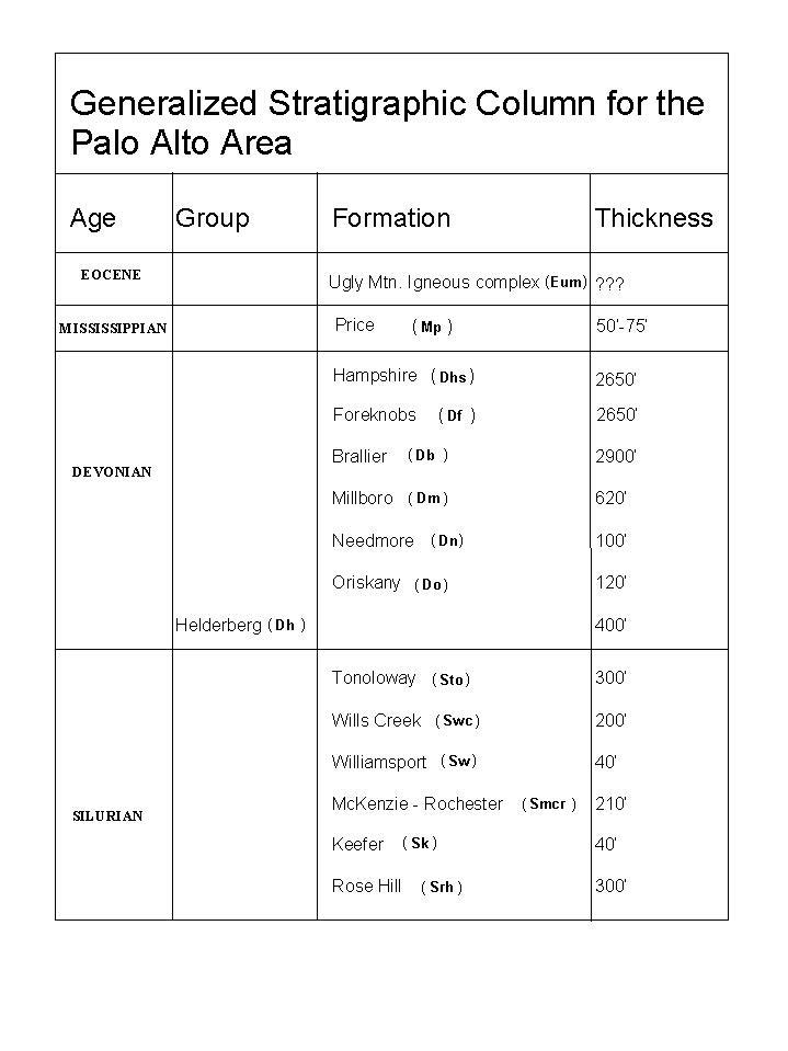 Sedimentary rock units in the Palo Alto area range in age from Silurian through Mississippian. Reconnaissance and mapping in
the quadrangle indicates "moderate" levels of structural complexity. In general, the regional strike for deformed strata in the
quadrangle is within the range N25°E to N40°E. The two most prominent structural features are the Shenandoah Mountain
Syncline in the southeast corner of the quadrangle and the Stone Mountain Anticline in the northwest. The only other major
structural element of note is a possible overthrust contact between the Devonian Foreknobs Formation and the underlying Devonian
Brallier Formation near Brushy Fork Dam in the west-central portion of the quadrangle. Numerous small-scale faults (probable
displacements of 1 meter or less), joints, and folds were encountered in several of the less competent rock units, namely the
Devonian Foreknobs, Brallier, and Millboro formations and the Silurian Tonoloway Limestone. In general, none of these deformations
was mappable at a 1:24,000 scale. Several of these units are intruded along planes of weakness by igneous rocks associated with
the Ugly Mountain Igneous complex.
Sedimentary rock units in the Palo Alto area range in age from Silurian through Mississippian. Reconnaissance and mapping in
the quadrangle indicates "moderate" levels of structural complexity. In general, the regional strike for deformed strata in the
quadrangle is within the range N25°E to N40°E. The two most prominent structural features are the Shenandoah Mountain
Syncline in the southeast corner of the quadrangle and the Stone Mountain Anticline in the northwest. The only other major
structural element of note is a possible overthrust contact between the Devonian Foreknobs Formation and the underlying Devonian
Brallier Formation near Brushy Fork Dam in the west-central portion of the quadrangle. Numerous small-scale faults (probable
displacements of 1 meter or less), joints, and folds were encountered in several of the less competent rock units, namely the
Devonian Foreknobs, Brallier, and Millboro formations and the Silurian Tonoloway Limestone. In general, none of these deformations
was mappable at a 1:24,000 scale. Several of these units are intruded along planes of weakness by igneous rocks associated with
the Ugly Mountain Igneous complex.
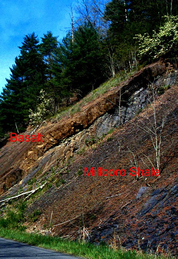 Sill of porphyritic, amygdaloidal basalt overlying steeply dipping (60°) strata of the Devonian Millboro Shale, south of
Sugar Grove, West Virginia. The sill is approximately 1 meter thick and is amygdaloidal to vesicular at the contact margins.
Alteration of the country rock is limited to a slight, local phyllitization which causes the "shiny" appearance of the Millboro
near the contact. The fine-grained nature of the sill material suggests shallow emplacement and rapid cooling.
Sill of porphyritic, amygdaloidal basalt overlying steeply dipping (60°) strata of the Devonian Millboro Shale, south of
Sugar Grove, West Virginia. The sill is approximately 1 meter thick and is amygdaloidal to vesicular at the contact margins.
Alteration of the country rock is limited to a slight, local phyllitization which causes the "shiny" appearance of the Millboro
near the contact. The fine-grained nature of the sill material suggests shallow emplacement and rapid cooling.
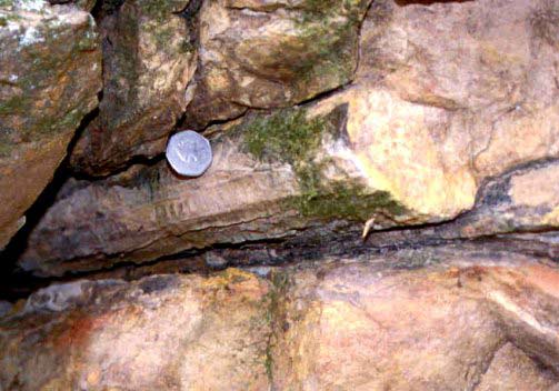
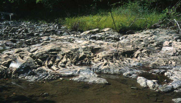 A dike exposed in Brushy Fork Creek, approximately 2 miles east of the sill shown in the previous image. The tan-colored rock
is an albitite (Garnar, 1951, 1956) composed almost exclusively of sodium plagioclase (albite) and minor amounts of magnetite.
The dike is approximately 8-10 meters wide and trends N80°E, appearing to radiate eastward from Ugly Mountain. Cooling
fractures in the dike give the appearance of "pseudo-sedimentary" structures and the fine-grained nature of the rock makes it
easily mistaken for a fine-grained sandstone.
A dike exposed in Brushy Fork Creek, approximately 2 miles east of the sill shown in the previous image. The tan-colored rock
is an albitite (Garnar, 1951, 1956) composed almost exclusively of sodium plagioclase (albite) and minor amounts of magnetite.
The dike is approximately 8-10 meters wide and trends N80°E, appearing to radiate eastward from Ugly Mountain. Cooling
fractures in the dike give the appearance of "pseudo-sedimentary" structures and the fine-grained nature of the rock makes it
easily mistaken for a fine-grained sandstone.
 Cast of a charcoalized log at the base of a sandstone bed within the Devonian Hampshire Formation, Shenandoah Mountain National
Forest, Augusta County, Virginia. "Ribbing" and striated structure on the exterior of the log represent the impressions of burnt
"bark," an indication a Devonian forest fire followed by high-energy stream flow and subsequent deposition of debris from the event
at the bottom of a stream channel.
Cast of a charcoalized log at the base of a sandstone bed within the Devonian Hampshire Formation, Shenandoah Mountain National
Forest, Augusta County, Virginia. "Ribbing" and striated structure on the exterior of the log represent the impressions of burnt
"bark," an indication a Devonian forest fire followed by high-energy stream flow and subsequent deposition of debris from the event
at the bottom of a stream channel.
Exposures of many of the rock units in the Palto Alto quadrangle are limited to road and stream cuts. Continuous outcrop is
rare with the exception of exposures of Millboro Shale and Brallier Formation along Sugar Grove Road. Everywhere else, the precise
placement of formation contacts is extremely difficult. Most rock units show the effects of weathering but fresh samples could be
obtained from all units except for some of the highly mafic intrusives associated with the Ugly Mountain Igneous Complex, which
were reduced to clay-rich colluvium.
Geochemical investigations noted relatively elevated concentrations of barium, iron, manganese, zinc, and vanadium in the
quadrangle. Precious metal analyses showed sporadic, non-economic gold concentrations (< 40 ppb) within the Millboro Shale and no
direct connection to the igneous intrusives. High barium concentrations are uncorrelated with any particular rock type. Analyses
of igneous intrusives and country rock in contact give no indication of mineralization or geochemical alteration of the country
rock. This suggests "dry" emplacement of the igneous rocks or minimal fluid exchange between intrusives and country rock.
Elevated levels of iron and manganese show an apparent correlation with fracturing and faulting, indicating recementation of
country rock by iron- and manganese-rich fluids following deformation.

 Page last revised: November 11, 2005
