WVGES Mission, Information, and History

MISSION STATEMENT
The West Virginia Geological and Economic Survey conducts long-term and project-specific, independent and unbiased analysis of the geology of the state and provides scientific expertise, information, and education to all of West Virginia's stakeholders regarding the coal, natural gas, petroleum, non-fuel resources, environmental concerns, karst, and geologic hazards of the state.LOCATION
             Physical and      West Virginia Geological & Economic Survey
             Mailing Address:  Mont Chateau Research Center
                               1 Mont Chateau Road
                               Morgantown, WV  26508-8079
                   Telephone:  304-594-2331
                         FAX:  304-594-2575
                      E-mail:  info@wvgs.wvnet.edu
                       Hours:  8:00am-5:00pm, Monday-Friday
	   Publication Sales:  8:00am-4:00pm, Monday-Friday
                               (Closed holidays)
                  Directions:  location map and directions
CURRENT DIRECTOR
Director and State Geologist: Jessica Moore
FUNCTION
The West Virginia Geologic and Economic Survey...
- is West Virginia's center for geology, energy resources, industrial minerals, geologic hazards, ground water, topographic and geologic maps, earth science, and much more;
- conducts applied and original research on the coal, oil, and natural gas resources of West Virginia;
- maps economic coal beds, oil and gas fields, geologic hazards, subsurface geologic units, and bedrock and surficial deposits in the state;
- tracks oil and gas drilling, coal mining. and other geologic resource extraction activities;
- collects and analyzes coal and rock samples, and maintains a repository of samples and cores;
- disseminates results of geoscience investigations to the public through publications, website, outreach, and responses to direct inquiries from the public, industry, government agencies, and academia; and
- provides maps, publications, consultations, selected database items, and copies of documents at modest cost.
HISTORY
"Experience has shown but one way in which to open up the resources of a country, and this is a geological Survey...." With these words in 1869, distinguished West Virginia University geologist John James Stevenson advocated the State's need for a geological survey.
In 1897, the West Virginia Geological and Economic Survey (WVGES) was established by an act of the Legislature to investigate the State's geological and physical resources, make the results of these investigations promptly available to the public, and provide topographic, geologic, and other maps of the State.

The Survey's first Director
I.C. White
Chosen to head the new Survey was Dr. Israel Charles White, one of the most prominent geologists of that time. Under his leadership, the Survey soon became internationally known.
By 1927, the Survey had made detailed geologic studies of every county except Greenbrier and topographic maps covering the entire State.
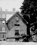
The Survey's first home
In 1934, Dr. Paul H. Price assumed the position of Director and State Geologist and the Survey entered a new period where extensive coal, oil, and natural gas studies were undertaken. In 1941, Dr. Price initiated a cooperative U.S. Geological Survey program to study the ground-water resources of the State. In 1942, the Survey moved into West Virginia University's new Mineral Industries Building, later renamed White Hall in honor of Dr. I.C. White.
Map publishing reached a new high in the postwar years of Dr. Price's directorship and included a new State geologic map, shaded relief map, base map, mineral resources and mineral industries map, three editions of an oil and gas map, a limestone map, and, under a cooperative agreement with the U.S. Geological Survey, nearly 300 topographic maps.
By the late 1960s, geologic information increasingly became part of land-use planning, water-resource management, building construction, planning of transportation and utility facilities, and the safe disposal of wastes. Consequently, when Dr. Robert B. Erwin became Director and State Geologist in 1969, the Survey enlarged the scope of its activities to include detailed statewide coal studies, land-use mapping, remote sensing, sophisticated analytical capabilities, and computerized data processing.
Under Dr. Erwin, the Survey established its unique Coal Program and began a comprehensive reevaluation of the geology, composition, and extent of all 117 West Virginia coal seams. Increased study of nonfuel mineral resources and important acid mine drainage research was conducted. Computerization of the Survey's enormous quantity of geologic data was undertaken. Significant publications were completed such as the fiftieth anniversary edition of Springs of West Virginia, and the West Virginia Gazetteer of Physical and Cultural Place Names. The Survey relocated to Mont Chateau Research Center, allowing most of the staff to be housed in one building.
Larry D. Woodfork became Director and State Geologist in 1988 and led the Survey through Devonian Shale studies, USGS-supported geologic mapping projects, the implementation of the cooperative Mineral Lands Mapping Program that developed numerous layers of digital GIS information related to coal resources, coal land ownership (partnering with the Tax Department), and topographic base maps (with the GIS Technical Center at WVU), and the creation of the State's GIS coordination office. An Atlas of Major Appalachian Gas Plays was published, and web-based services and data were developed. For 16 years, the agency conducted intensive summer geology programs called "Rock Camp" for West Virginia science teachers, initially supported by the National Science Foundation with subsequent funding from the State. The agency also developed a "mini-museum" in its lobby to showcase specimens from around the area.
In 1997, the Survey's 100th anniversary found the agency expanding public service and outreach functions, participating in an increased variety of externally funded research projects, and fully computerizing nearly all geoscience and support functions.
Carl J. Smith became Director and State Geologist in 2002. He continued several of the on-going programs and led the agency into the development of digital publications. The Survey became part of the Department of Commerce and began new studies in carbon sequestration and oil fields.
Dr. Michael Ed. Hohn, took over as Director and State Geologist in 2006, continuing work on Appalachian tight gas sands, studies of the Marcellus, Utica-Point Pleasant, Rogersville, and other shale reservoirs, resource assessments, and geothermal energy. Bedrock geology mapping in the State, including the Gauley River, Bluestone River, and New River areas for the National Park Service, resulted in several digital geologic maps available in paper form or as GIS databases. The agency completed a Broadband Mapping Program and expanded web-based interactive mapping services.
Dr. B. Mitchel Blake, Jr., became Director and State Geologist in January, 2018, and work continued on coal-bed mapping, shale-gas reservoirs, geothermal energy, web-based interactive mapping services, and geologic mapping. The agency's facility underwent much needed infrastructure improvements and staff investment, including increasing data speeds to better serve the public through the Survey web site.
As of January 1, 2021, the Director and State Geologist is Jessica Moore. Under Jessica's direction, the Survey remains committed to maintaining its long tradition of technical excellence and professionalism, and to providing quality public service to all West Virginians.
I.C. White's Address to Governors
"The Waste of Our Fuel Resources", Remarks presented by I.C. White, State Geologist of West Virginia To the Conference of the Governors of the United States The White House, Washington, D.C., May 13 - 15, 1908. ( PDF, 586 KB)