STATEMAP Project for 2014:
Lake Sherwood and Mountain Grove Quadrangles

Preliminary Bedrock Geologic Map of the Lake Sherwood and West Virginia Portion of the Mountain Grove Quadrangles, Open-File Publication OF-1404
Principal Investigators: Paula Hunt, Ronald McDowell, Jeanne Sutton, and Philip Dinterman (WVGES)
Geological Assistant: Mary Sue Burns (Pocahontas County High School, Dunmore, WV)

Bedrock Geology of the Lake Sherwood Quadrangle and the West Virginia portion of the Mountain Grove Quadrangle
The West Virginia Geological and Economic Survey (WVGES) mapped the bedrock and collected rock samples for geochemical analysis on the Lake Sherwood and Mountain Grove, West Virginia-Virginia quadrangles (see location map) from June 2014 through May 2015. WVGES investigators Paula Hunt, Ronald McDowell, Jeanne Sutton, and Phil Dinterman were assisted by Mary Sue Burns (Pocahontas High School, Dunmore, WV) during the field season. Funding for Ms. Burns' salary and field expenses was provided by the West Virginia Geological and Economic Survey and the United States Geological Survey (USGS).
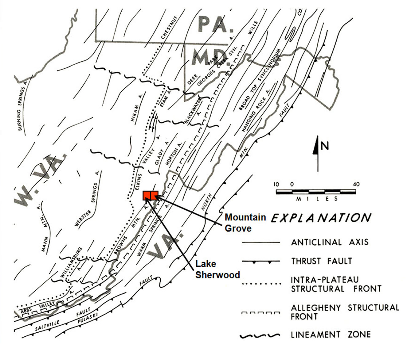
The map area is a continuation of bedrock mapping from north to south along the strike of the Brown's Mountain Anticlinorium, which lies between the Allegheny Front to the east and the Appalachian Plateau to the west (see physiographic province map below). As a result, the area exhibits a mixture of moderate to very complex deformation. This deformation takes the form of folding and faulting and is most notable in the western portion of the Lake Sherwood Quadrangle. Strikes, fold axes, and fault traces generally trend northeast-southwest. Intense folding in the western portion of the study area associated with the Brown's Mountain Anticline was probably initiated by thrust faulting deeply "rooted" in Silurian or Ordovician shales present in the subsurface. Deformation propagates readily through overlying units resulting in west-vergent compressional folding of strata in the area. Small-scale features and mineralization provide some of the most notable and photogenic evidence of this deformation in the map area.
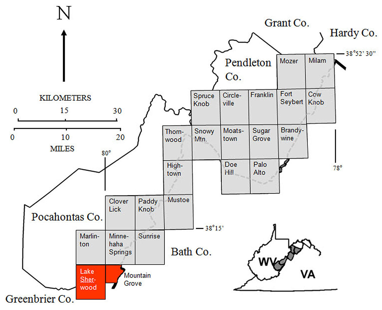
Location of the map area in red with previous STATEMAP project locations in gray (click to enlarge).
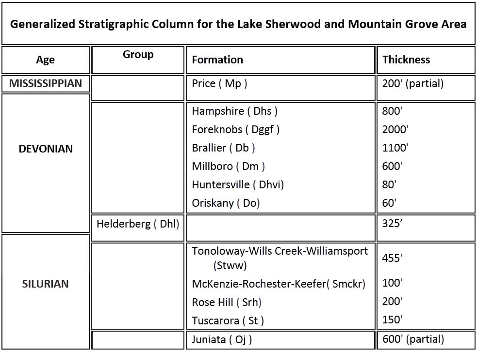
Stratigraphic units encountered in the Lake Sherwood and West Virginia portion of the Mountain Grove area range in age from Ordovician through Mississippian. (Click to enlarge.)
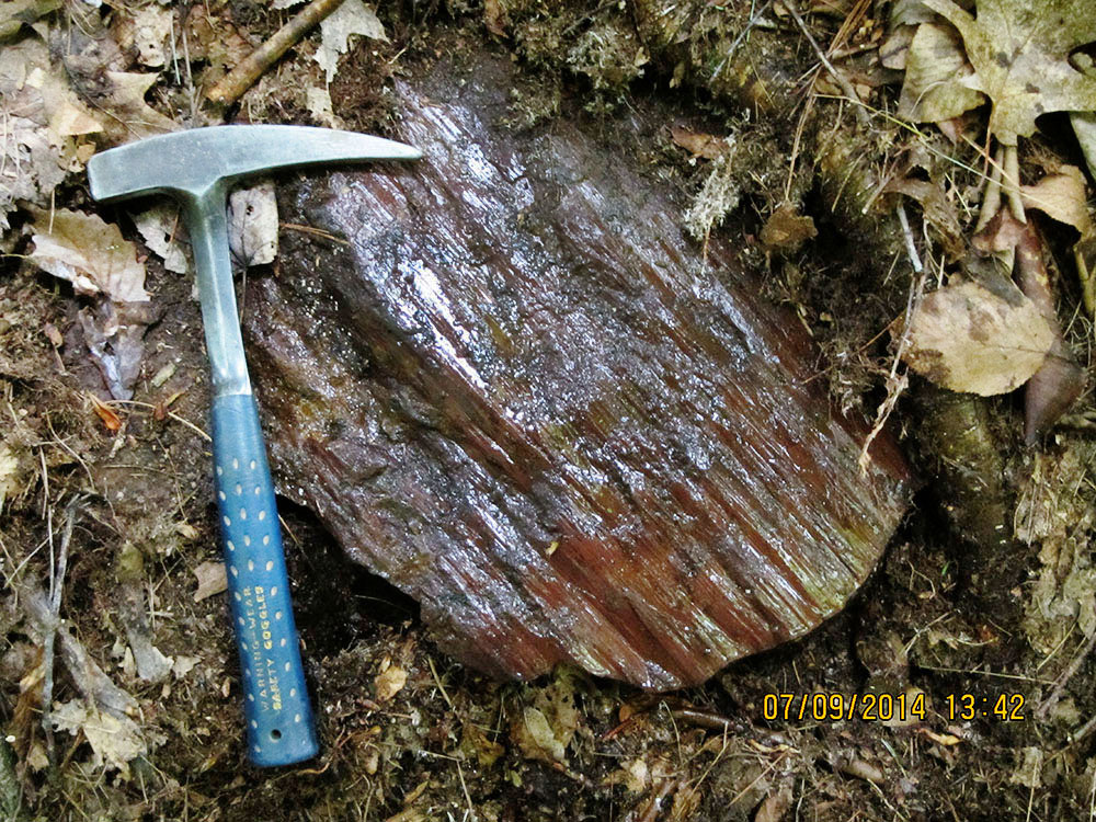
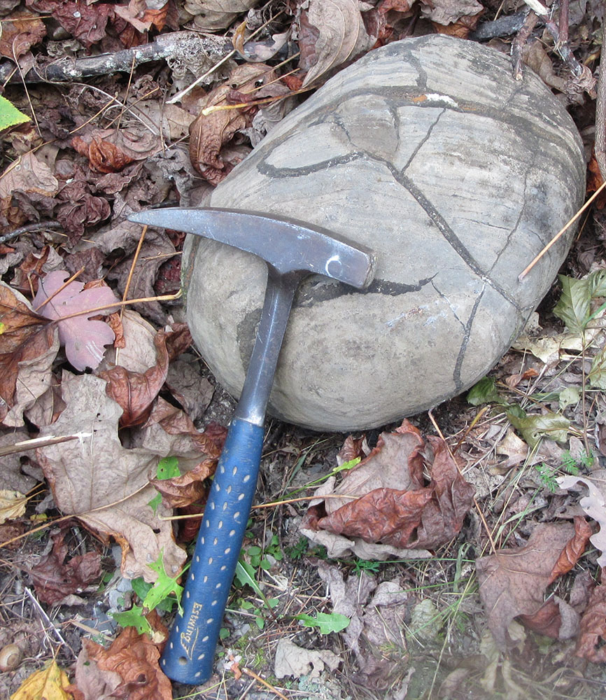
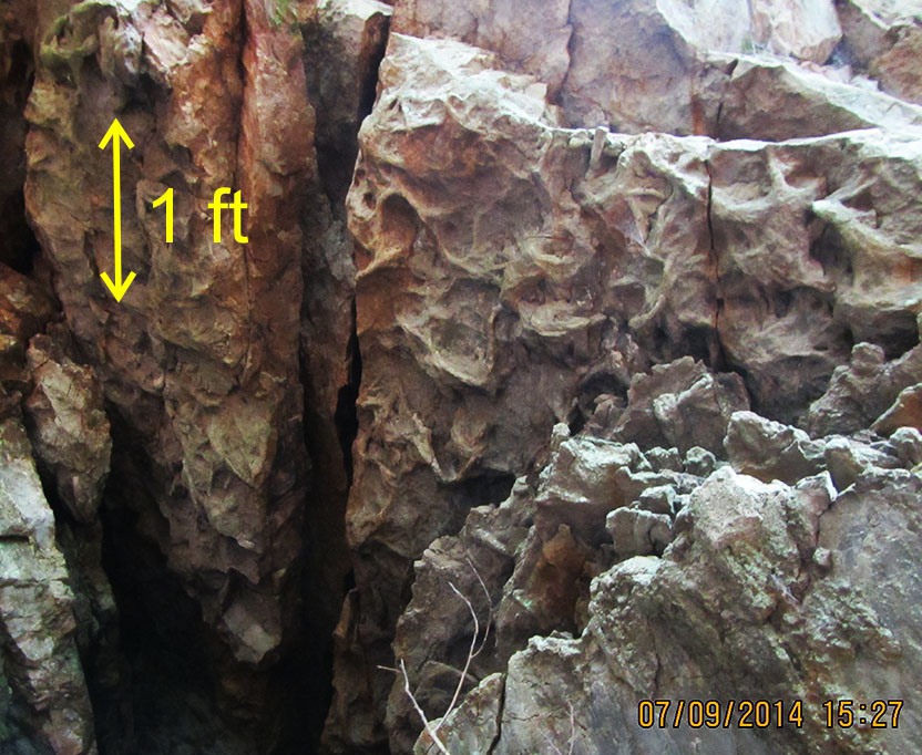
A small boulder of Silurian Rose Hill Formation shows well-developed slickensides probably associated with fault motion; rock hammer for scale. Location: Near Beaver Creek in Calvin Price State Forest, Pocahontas Co., WV. (Click to enlarge.)
In the project area, brecciated, brittle rock units like the Silurian Tuscarora and Devonian Oriskany Sandstone were frequently observed to be mineralized with iron and manganese oxides and hydroxides. In the 1800s, several mineralized exposures of Oriskany were mined for iron ore (Grimsley, 1909). The authors located (with difficulty) two of those former mining prospects and collected samples for geochemical analysis.
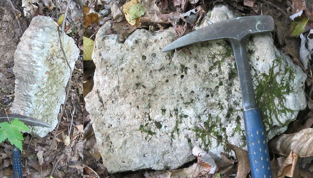
Carbonate septarian nodule eroded out of the Devonian Millboro Shale; rock hammer for scale. Location: Beaver Lick Mountain, Monongahela National Forest, Greenbrier Co., WV. (Click to enlarge.)
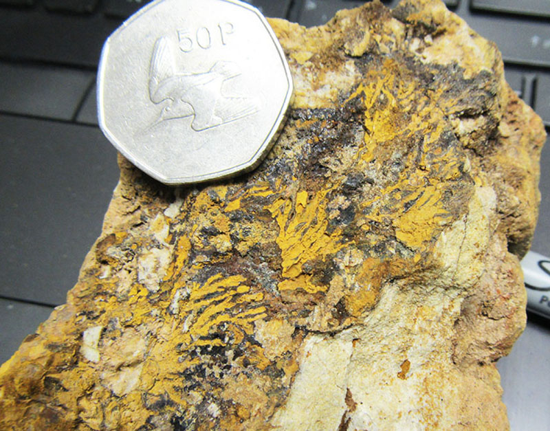
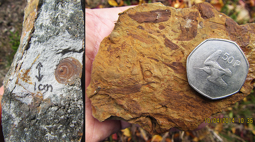
Silurian Tuscarora Sandstone with a mineralized layer coating a fracture surface. Root-like pattern probably represents goethite (iron hydroxide FeO(OH)) replacement of manganese dendrites. The orange coloration is from subsequent alteration of goethite to limonite (hydrous iron hydroxide FeO(OH)·nH2O) during weathering. Coin is 3 cm in diameter. Location: Beaver Lick Mountain, Monongahela National Forest, Pocahontas Co., WV. (Click to enlarge.)

WVGES geologist Paula Hunt investigates part of the surface exposure at the Dan iron prospect developed in deformed Devonian Oriskany Sandstone. Location: Beaver Lick Mountain, Monongahela National Forest, Pocahontas Co., WV. (Click to enlarge.)
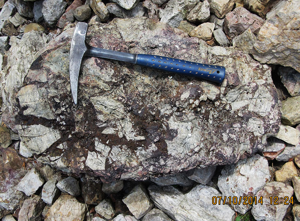
Brecciated Oriskany Sandstone recemented with iron minerals, primarily goethite. The inclusion of the clasts of sandstone reduces the value of this material as iron ore but analysis showed that that this mineralized breccia still contains more than 20% iron by weight. Rock hammer for scale. Location: Beaver Lick Mountain, Calvin Price State Forest, Pocahontas Co., WV. (Click to enlarge.)
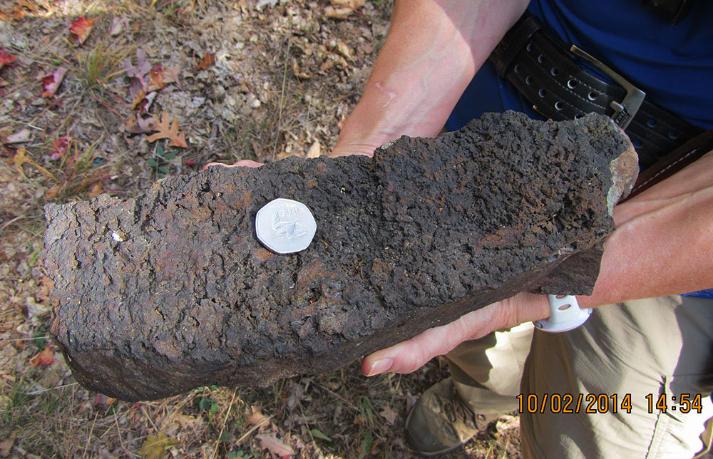
Sample of ore from the Fertig iron prospect. ''Spongey'' goethite ore is concentrated in fractures in deformed Oriskany Sandstone. This material has an iron content of more than 40% iron by weight. Coin is 3 cm in diameter. Location: Beaver Lick Mountain, Monongahela National Forest, Greenbrier Co., WV. (Click to enlarge.)
Numerous Arthrophycus sp. on the bottom of a Tuscarora Sandstone bedding surface. NOTE: this is an unusual variant of Arthrophycus sp., with much more penetration of the trace into the underlying shale layer (now removed by erosion). This is probably not Arthrophycus alleghaniensis, the ''type'' trace fossil for the Tuscarora. Location: near Beaver Creek, Calvin Price State Forest, Pocahontas Co., WV. (Click to enlarge.)
In previous years, the Silurian Tonoloway, Wills Creek, and Williamsport formations have been observed as distinct mapping units, and, further north along the West Virginia/Virginia border, the Silurian McKenzie and Keefer formations are differentiable. However, heavy vegetation and soil cover and limited exposure hamper the delineation of all formation contacts except for the most resistant units. For the current mapping project, the Tonoloway, Wills Creek, and Williamsport were mapped as a single unit; the McKenzie and Keefer were also treated as a single unit. The Tuscarora Sandstone in the map area is the most consistently recognizable Silurian unit. Not notable for the presence of body fossils, the Tuscarora did yield identifiable trace fossils at several localities, as shown in the photos.
Trace fossil Diplocraterion sp. in a Tuscarora boulder. Aside from Arthrophycus sp., the other trace fossil most commonly described from the Tuscarora is "Skolithos" sp., but this trace is frequently a misidentification of the "u-tube" Diplocraterion sp.. The side view of the boulder (left) shows a collection of simple, vertical tubes which does fit the description of Skolithos sp. However, examination of the top of the boulder (right), reveals that the tubes are actually the paired vertical "limbs" of Diplocraterion sp. Rock hammer for scale. Location: Beaver Lick Mountain, Monongahela National Forest, Greenbrier Co., WV. (Click to enlarge.)
Other rock units in the project area, especially the Devonian Foreknobs Formation and the other formations at the top of the stratigraphic section, did contain interesting and sometimes spectacular body fossils. Left, a large, orbiculoid, inarticulate brachiopod (Orbiculoidea? sp.) in the Devonian Huntersville Chert. Notice that the Chert weathers to a "gritty" surface that probably indicates an original content of volcanic ash associated with one of the Tioga eruptive events. Right, a highly limonitized sample of the Devonian Foreknobs formation showing a mixture of molds of marine crinoid columnals and casts of pieces of "driftwood" from a Devonian forest. Coin is 3 cm in diameter. Location: Beaver Lick Mountain, Monongahela National Forest, Greenbrier Co., WV and Middle Mountain, Monongahela National Forest, Pocahontas Co., WV. (Click to enlarge.)
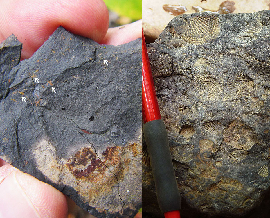
Left, tiny, limonitized examples of the problematic mollusc? Styliolina fissurella (arrows). This fossil is an index fossil used to recognize the Devonian Millboro Shale. The small size of this and other fossils in the Millboro is thought to be an indicator of poor environmental conditions during deposition of the Millboro. Right, a large number of the brachiopod Spinatrypa sp. in the Devonian Foreknobs Formation. Portion of the pencil visible in the photo is about 2.5 inches in length. Location: Beaver Lick Mountain, Monongahela National Forest, Greenbrier Co., WV and Calvin Price State Forest, Pocahontas Co., WV. (Click to enlarge.)
GEOCHEMICAL ANALYSES
A total of 17 bedrock samples were collected for geochemical analysis during the field season. These analytical results have been combined with results from past year's STATEMAP projects in a geochemical database available to the general public as West Virginia Geological Survey Report of Investigations RI-34 (McDowell, 2001). Concurrent with this year's STATEMAP project, the geochemical database has been brought up to date and summary statistics fully revised. A GIS-compatible version of the database is currently available.
REFERENCES CITED
Grimsley, G., 1909, Iron Ores, Salt, and Sandstones, Volume 4: West Virginia Geological and Economic Survey, 603 p. More publication information is here.
Kulander, B. and Dean, S., 1978, Gravity, Magnetics, and Structure: Allegheny Plateau/Western Valley and Ridge in West Virginia and Adjacent States: West Virginia Geological and Economic Survey Report of Investigations RI-27, 91 p. More publication information is here.
McDowell, R., compiler, 2001, Stratigraphic Geochemical Database for Portions of Pendleton, County, West Virginia
and Adjacent Virginia Counties, covering portions of Pendleton Co., WV, Highland Co. VA, and Augusta Co., VA: West
Virginia Geological and Economic Survey, Report of Investigations RI-34, data file. More publication information is here.
PHOTOGRAPHIC CREDIT
Ronald McDowell and Mary Sue Burns